Showing posts with label Balkan. Show all posts

Monday, 1 February 2016

Stones with narrow bottomed bowls

In my post about bullaun stones, the ancient grinding stones, I mentioned that these types of stones are also found in the South Eastern Baltic are. This is one of many old hollowed stones from the Baltic. They are called bowl stones and are, like in Ireland and in Slavic countries, regarded as sacred. The place where the stone is located is used as a place of worship. The diameter of this stone is about 60 cm and a depth - about 15 cm. In the past people considered the accumulated water as sacred and thought that it had healing properties. In the past the stone used to be called the stone of god.


You can see many more of these stones if you run this search. Here are some of them. This one is called "Lielais Daviņu Akmens" which means great stone of giving, offering, great altar. It seems that the stone was linked to harvest rituals.


This stone stands on a hill, where an old oak forest grew until the seventeenth century. The hill was a site of a pagan temple. 


For information about these stones in English look at the pages 27 - 33 of the book "Studies into the Balts’ Sacred Places".

I was just made aware of an article about an interesting half-made bowl-stone from Baltic region. On its top part there's a circular groove of a similar size as the usual bowls on other stones, as if someone had intended to gouge out a bowl there too but stopped half way through the process of gouging the hole. 


We can deduce though that this is how these bowl stones were actually made from their name in Lithuanian. Lithuanian word for bowl is dubuo, dubeni akameni...These words come from Slavic root dub meaning wood, oak but also to gouge. This second meaning comes from the time when utensils were made by gouging bowl like holes in pieces of wood and later stone. In Southern Slavic languages Dubiti means to gouge and Dubeni, Dubeno means gouged, with a gouged hole, bowl in it...Dubeni kameni in South Slavic languages means gouged stones, bowl stones...

But there is a special kind of these bowl stones which are found in the South Eastern Baltic that fall into a class of their own. These are so called "stones with narrow bottomed bowls". 


There are all together 250 narrow-bottomed bowls, but it is quite possible that more once existed, but were destroyed. Majority of these stones are concentrated in two areas: Central and Northern Lithuania / Central Latvia and in Eastern Lithuania. Only a couple of such stones were found in Samogitia.

Historical and archaeological records show that the stones with narrow bottomed bowls are very similar in dimensions and shape, regardless of the area in which they were found. The dimension homogeneity is quite stunning. Processed or unprocessed, the size of the stones varies only slightly. 


They are only in exceptional cases smaller than 60 x 70 cm and never exceed 100 x 120 cm. Stones thickness (height) is also very similar and varies between 25 - 35 cm. Several stones found in-situ protrude above the ground plane from 5 - 15 cm. The diameter of the upper part the bowl is rarely less than 15 - 16 cm and is never more than 23 - 24 cm. The bowls dept varies between 9 and 21 cm.


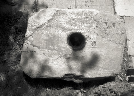
The stones are usually found on farms: near houses, barns and cattle sheds or inside them, quite often at the base of the building. Often there are 2 to 3 or even 4 to 5 stones with narrow bottomed bowls preserved in every village, for example Montviliskis, Vaiduloniai, Vileikiai. Today most of these stones are used as decorations. Sometimes these stones are used in churches for storing holy water, like in Dotnuva. But it seems that they were once used as corner stones, usually placed under the northern or north western corner of the house. 

Up until the seventeenth century it was customary to build wooden buildings without diging foundations. A layer of stones was placed on the ground and then the wooden house frame was built on top of it. Corner stones were the most important of all as they were placed under the main four supporting vertical beams. The bowl in the corner stone was usually oriented towards the inner side of building. 


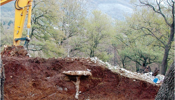
The archaeological investigation which was carried near 9 of these stones dated them to the period 16th - 17th century. However, excavation near the Montviliskis stone uncovered two holes of about one meter in diameter full of ashes, cattle bones and potsherds dated to 2nd millennium AD as well as potsherds from the period 16th - 18th century. The bones were all of young animals, indicating that they were sacrificed in a "first fruits" kind of sacrificial fertility ceremony.

There are ethnographic records from Lithuania which show that in the past, when the corner stones were placed in the ground, a special blessing and sacrifice ceremony was performed.  The hole in which the corner stone was to bi placed was dug first. Then the owner of the house would step into the hole and would drink some vodka and then all the workers working on the house would do the same and then they would share some food and continue working. The corner stones were marked with wax crosses and money was placed next to or under them. It was believed that god lived in them. Not only that, but it seems that the stones with narrow bottomed bowls were used as family altars.

At the beginning of the 17th century Jesuits described the stones with narrow bottomed bowls calling them "Deiviu akmenys" meaning "Goddess stones".
The report  from the 1600 says: In stores big stones are kept. They are dug into the ground, with the flat faced facing up. They are covered with straw. They are called "Deyves" (Goddesses) and are faithfully worshiped as the protectors of cereal and cattle.
The report from 1605 says: Some very uneducated village people due to our efforts got rid of the bad habit of worshiping one stone which they thought to be the god of granary, fruitfulness and happiness of home.

Even though it is not specifically stated that the sacred stones were "bowled", there is much in common between the stones described by Jesuits and stones with narrow bottomed bowls: their location in farm buildings, the fact that the top face of the stone was flat, the stones had the function of the cereal, cattle, happiness provider.

There are legends about the stones with narrow bottomed bowls which state that in the old times they were used as mortar stones for milling, grating or pounding. In Veriskiai, the local legends states that the stone was used by the Devil to grind tobacco.

Some stories preserved by old people talk about holy water being stored in the stones and that before that people used to pour milk into the hole for the grass snake, the houses snake, the incarnation of the house protector spirit in Balto Slavic religion.

In the 17th century Jesuits recorded the existence of a god called "Pagirinis", meaning "The one who lives under the quern, under the mortar stone" basically "The one who lives under the stone with narrow bottomed bowl". Knowing this it seems that the most probable function of the stones was as an altar to the god (goddess) protector of home. Another 17th century Jesuit report states that the god "Pagirinis" sometimes comes out of his corner in a shape of a grass snake, but that it spend most of his time buried in the soil, which is kept in a clay or wooden dish or without a dish under the quern (mortar stone, the stone with the narrow bottomed hole).

So this is very interesting. We have:

1. a corner stone
2. which is shaped like an ancient mortar stone
3. which was used as a fertility cult altar.
4. which is referred to as a "Goddesses stone"
5. which is the home of the male deity whose name means "The one who lives under the quern, under the mortar stone"

In some parts of Serbia the " thick wall" made of stone which supports the house is called Baba.


In Bulgaria thick logs which are put under log cabin corners to support the house are called "bа́bka". This gives additional meaning to the Serbian proverb that says that "the house stands on a woman". I wrote about it in the post "Baba - the main column, pole that supports the house". It seems that baba was any supporting structure on which the house stood. 

In Serbian and in other Slavic languages the word Baba also means wich, goddess,  and not just any goddess, the Mother Earth. So it is not surprising that the above corner stones from Lithuania were called "Goddesses" stone. They are basically Baba's stone, as Baba, Mother Earth,  was the fertility goddess to which Lithuanians prayed to. Interestingly

The name of the male deity which is believed to live under the corner stone in Lithuania shows that that these stones were once actually used as grinding stones, as I postulated in my post about bullaun stones.

The fact that the mortar grinding stone was used as a fertility altar dedicated to the Mother Earth is not surprising at all either. A hole in the ground is where the plant seed is planted. A hole (vagina) in the lying woman is where human seed is planted. So a horizontal lying stone with a hole (mortar) is already suggestive enough. Mortar grinding stone and pestle even more. So much so that the mortar and pestle became the symbol of male and female genitalia in Hinduism (Yoni and Lingam).

This is a so called "wet" grinder mortar and pestle from India from this great blog post about making stone ground chutney


And this is Yoni and Lingam 


The union of sky and earth produces (releases) cereal seeds which are then poured into the mortar and pounded into flour with pestle in a motion which greatly resembles coital movement of penis (Lingam) inside vagina (Yoni) which produces (releases) human seeds which are poured into the vagina.... Do you see the link here? The fact that in the Baltic tradition milk was poured into bowl of the corner stone "for the snake to eat" confirms this, milk being symbolic replacement for sperm, milky white liquid containing human seeds. Once the cereal seeds are pounded into the flour flour is made into bread which is bake inside the bread oven which looks like the belly of a pregnant woman. And that bread oven is in Serbia called baba. Ovens were in old Slavic houses placed in north-eastern or north-western corner, just like the Goddess stones. 


The belief that the house protector snake lives in the house foundation does not only exist in the Baltic countries. It is wide spread in Slavic countries and it exist in Serbia too. In Serbia the house protector snake is believe to live in the house heart (stone oven) or the house foundations (the layer of stones which supports the wooden house frame, corner stones originally). It is believed that this snake is the spirit of the founder of the family, some other very distinguished ancestor, or the first male ancestor who died in the house. Either way this snake is the symbol of the male ancestor, just like Lingam. So we have a mortar stone (Yoni) which houses (in a bowl) snake (Lingam)...

And this is it, the story about Lithuanian co called "stones with narrow bottomed bowls". I hope you enjoyed it. Until the next time, stay happy.

References

"Aukštaitiški aukurai" by Vykintas Vaitkevičius
"Studies into the Balts’ Sacred Places" by Vykintas Vaitkevičius
"Pojmovnik Srpske kulture - baba" - Etnografski institut SANU

Thursday, 30 July 2015

Mogila na Rake


Several early Bronze age tumulus graves have been discovered and excavated in Montenegro in last 10 years. They are concentrated in the fertile Zeta and Bojana valleys, both of which are linked to the Skadar lake. I already wrote about the Bjelopavlići tumulus. This time I will write about the tumulus known as "Mogila na rake" or "Spič tumulus" which was discovered in 2011.

Spič tumulus (Mogila na rake)

Tumulus which was found in the Spič field just south of Sutomore, under the Nehaj fortress is a tumulus type grave with a central dolmen cist which was built from a massive stone plates. It is estimated to be almost 5000 years old, dating to the early 3rd millennium BC, more precisely to 2700 BC. This is one of the so called princely graves common for southern Europe of that period.

This is a completely new archaeological locality. It was discovered by pure accident while people were clearing part of an old forest to build a house. Here is a picture of the first sight of the dolmen cist emerging from the tumulus mound.


This is what the dolmen cist looks like after all the soil was cleared away.


According to the archaeologists the tumulus was built by the people who belonged to the early bronze Age Ljubljana culture. This culture seem to have stretched along the whole East Adriatic coast. It also seem to have stretched inland into Bosnia and all the way to Sava and Danube where it could have had contacts with Vučedol culture.

The original tumulus had the radius of about 15 m and the height of about 1.80 m. The dolmen cist is surrounded by a ring of stones, which ritually separates the land of the dead from the land of the living. The sacred area was carefully cleared and compacted. It was then covered with fine dry soil and then treated with fire. Only then the central dolmen was built. The dolmen was made from massive stone plates. The person buried inside this dolmen cist was buried in a foetal position. This symbolizes rebirth after death and points to a belief that the death was seen as a new birth. Once the deceased was placed inside the cist, the cist was sealed with several types of clay, making the grave completely watertight The inside of the grave was as dry as when it was initially sealed almost 5000 years ago.  

This is the translation of the excavation report filed by archaeologist Mladen Zagarčanin who lead the excavation:

The Early Bronze Age tumulus “Mogila na Rake“ from Sutomore was found on the northeastern part of Spič field, about 1 km from the sea. The big earth-stone tumulus which had diameter of about 15 m, and height of about 1.80 m. It was discovered during the works related to the clearing of a private land with the use of diggers. During the dig the majority of the western and northeastern part of the tumulus was destroyed. The excavation work stopped when the digger uncovered the cover plate of the central tomb dolmen cist.

This is a rough cross section diagram of the tumulus:


The tumulus was covered with a layer consisting of large river pebbles.


After removing the stone layer the removal of the red-brown earth layer, about 0.80 to 1.00m thick, was carried out. There were almost no stones in this layer, although now and then one could notice particles of grime, small fragments of broken flint and small pieces of atypical pottery. The excavation of the earth mound confirmed the dense concentration of small and big stones, about 1.20 m thick, from which the stone layer was formed, covering the middle of the conical pile of pressed red coloured clay. The diameter of this layer was about 3.20 m, and the height about 0.80 m.
Further excavation revealed, the layer of green-dark earth, partly mixed with grime, which was roughly piled along the dolmen cist walls up to 0.60 cm height. Several fragments of pottery were found in this layer, as well as larger amount of chipped stone , while a smaller flat stone construction was confirmed on the north side of the same layer. We can assume that this construction represents a stair abutting the tomb, and it could have served as a platform from where the person in charge of the burial carried out the ritual.

With the removal of the green-dark layer the base of lower stone covering was revealed, round in shape, and made of medium and small pieces of limestone (0.5 to 0.20 m) mixed with red-brown earth. The cist was built on this layer using local stones. The sides were  constructed from massive trapezoidal shape stone plates (1.40 × 1.00 m, about 20 cm thick), which were bonded with yellow waterproof clay.

The cist was covered with two massive rectangle shaped plates (1m x 1.20m and 1.80 × 1 m; 20 cm thick), a large amount of yellow green clay was added to the layer of green-dark clay, whose purpose was to cover the plates both above and below, providing in that way the hydro insulation of the tomb interior.

Before the funeral ceremony, the interior of the cist was covered with a layer of fine sea sand, and the body was put on top of it in a foetal position, with the head directed toward to west, arms folded at the elbow, and with folded legs.


The anthropological analyses showed that the buried person was a man in his forties or fifties who had serious problems with his spine during his lifetime. During the detailed bone examination, it was concluded that he suffered of osteoporosis, or bone loss. It was also concluded that arthrosis, or arthritis was present among the ilium bones, as well as diseases of peripheral joints because of degenerative changes in joint cartilage. The third bone disease was found in the lumbar area and sacrum. The deformation found here indicates that the deceased walked with problems during his lifetime and that he suffered great pain in his back. These diseases suggest that he spent much time on horse back, because those deformities are characteristic for riders.

What is very interesting is that this was not the only skeleton found in the cist.

The bones of a child 8-10 years old (teeth and parts of other bones were preserved) were found his legs, as well as a smaller number of bones of a person 25-30 years old. The archaeologists assume that those are the bones of close family members, perhaps his son and wife who died before him. The missing skull and other bones of the buried skeletons point to the possibility that their bones were excavated from some other place and put in this tomb later on. But there is also a possibility that the woman and the child were sacrificed and then buried with the man. 

The cist did not contain any metal objects which is strange for these types of graves from this period. This could mean that this is not a grave of a warrior but a person who was in some other way important. Like a priest.

What was found in the cist are two ceramic vessels: a jug and a shallow plate.

The plate has a thick ring shaped stand and was thus interpreted as a thurible, a vessel used for burning incense during rituals. The thurible is richly decorated on both sides. The cross shaped detail was drawn on the upper surface which was shaped as a shallow plate with the extracted front and rounded back part, formed by the ribbons filled with the crossed lines. The ribbon ornaments formed borders which go along the edge of the vessel. Two holes were made on the corners of the extracted part of the thurible. On the bottom, a star shaped detail was engraved, formed of triangle fields and filled with crossed lines.


Now have a look at the cross symbol drawn on the top surface of the thurible. Remember the grave is dated to 2700 BC:


Is this pattern just a decoration with no meaning? Well if the above incense burning vessel was the only vessel with this symbol found in Montenegro we could say that this is indeed just a meaningless decorative pattern. But exactly the same vessels were found in other tumuluses and some of them are even older than this tumulus and were dated to the end of the 4th millennium BC. Surely the pattern choice was deliberate and must have had some cultural or maybe even religious meaning. I will talk about these other tumuluses and why they are extremely important for understanding of the Early Bronze Age Irish history in my next post. For now, let me just ask you a question: do you remember the gold cross discs which the Early Bronze Age Irish copper miners loved so much? The ones I wrote about in my post Or -Ireland's gold

This is the pair of these "Irish" golden discs found in Monaghan, dated to 2200 - 2000 BC.


Remember that I said that these "Irish" cross discs were made from gold that was brought into Ireland from Cornwall? The gold which was, according to the Irish annals, brought to Ireland by Partholon? The same Pathalon which according to the Irish "pseudo histories" came from the Balkans, via Iberia sometime during the second half of the 3rd millennium BC? 

Please note the cross symbols on the discs. This is the same cross symbol found on the thurible from the Sutomore dolmen. Is this just a coincidence? I don't think so. Not just because there are several incense burning vessel with this symbol found in Montenegro. But also because the same tumuluses which contain the incense burning vessel with this symbol also contain golden discs with this symbol... And all of them predate the Irish gold cross discs and because it all fits perfectly into the story of Partholon found in the old Irish histories.

But more about it in my next posts. Until then stay happy.

Sunday, 26 July 2015

Ór - Ireland's Gold

The earliest evidence for gold working dates to the fifth millennium BC. This is based on the discovery of the Varna cemetery which is located approximately half a kilometer from Lake Varna and 4 km from the Varna city centre in Bulgaria. The cemetery was dated to the period 4,600 BC to 4,200 BC. The cemetery belonged to the Charcolitic Varna culture. The graves of this cemetery were full of  golden artifacts and they are considered to be the oldest golden artifacts in the world.


These Varna guys were obsessed with gold. As a matter of fact, just one of the graves from the Varna cemetery, the so called golden grave (grave 43) contained more gold, than has been found in all the other archaeological sites in the world from that epoch...

It seems that this love of gold was not universal. The surrounding Balkan cultures like Vinca Culture seem not to care very much for gold and the situation was pretty much the same in the rest of Europe at that time.

It took over a 1500 years for gold work to reach Britain and Ireland. The first gold objects appear in Ireland at the end of the third millennium (2200 BC). But it seems that once the Irish discovered gold, they became obsessed with it and couldn't have enough of it. But it seems that the Irish had a very peculiar and exclusive taste when it came to the type of gold objects they liked. A few of these kind of thingies were found in the Early Bronze age archaeological site:


But it seems that the favorite type of golden trinkets of the late 3rd millennium Irish were these two types of gold objects: a peculiar gold lunulae and even more peculiar gold cross discs:


The Gold lunula (plural: lunulae) is a distinctive type of late Neolithic, Chalcolithic or (most often) early Bronze Age necklace or collar shaped like a crescent moon. Most have been found in Ireland, but there are moderate numbers in other parts of Europe as well, from Great Britain to areas of the continent fairly near the Atlantic coasts. Although no lunula has been directly dated, from associations with other artefacts it is thought they were being made sometime in the period between 2200–2000 BC. A wooden box associated with one Irish find has recently given a radiocarbon dating range of 2460–2040 BC.

Beautiful things don't you think? The Irish seem to think so too. Of the more than a hundred gold lunulae known from Western Europe, more than eighty were found in Ireland.


Here some examples of European (Non Irish) gold lunulas and gold discs from "'Here comes the sun....' solar symbolism in Early Bronze Age Ireland" by Mary Cahill.

Lunula and a pair of gold discs from Cabeceiras de Basto, Portugal (© MuseuNacional de Arqueologia)


Pair of gold discs from Oviedo,Spain (© J. Camino Mayor, MuseoArqueológico de Asturias)


This is what you can read on the National Museum of Ireland's website about the 3rd millennium Bronze Age Irish gold craze:

The National Museum of Ireland’s collection of Bronze Age gold work is one of the largest and most important in western Europe. The immense quantity of Bronze Age gold from Ireland suggests that rich ore sources were known. 

Gold has been found in Ireland at a number of locations, particularly in Co. Wicklow and Co. Tyrone. The gold is found in alluvial deposits from rivers and streams. This gold is weathered out from parent rock and can be recovered using simple techniques such as panning. These gold deposits are still exploited today.

This gold is weathered out from parent rock and can be recovered using simple techniques such as panning. In Wicklow mountains this technique is still used today by prospectors to find gold nuggets as you can see on the below picture and this video.


The Wicklow Mountains form the largest continuous upland area in Ireland. They occupy the whole centre of County Wicklow and stretch outside its borders into Counties Carlow, Wexford and Dublin. Where the mountains extend into County Dublin, they are known locally as the Dublin Mountains


Wicklow mountains are criss-crossed with thousands of streams and a lot of them carry gold and some of them carry a lot of gold.

This is the Wicklow gold nugget (or more precisely its replica).


This gold nugget, weighing 682 grams is the biggest gold nugget found on British Isles. It was found in the Ballin valley stream which is located near the town of Avoca in County Wicklow, Ireland, in September 1795. A cast of the ‘Wicklow Nugget’ is held in the Natural History Museum in London. The stories of how the nugget was discovered are many. One story is it was found by workers felling trees on an estate owned by Lord Carysfort. Another that it was found by a local school teacher walking on the banks of what is now the Goldmines River. Either way the nugget sparked the first and only gold rush in Ireland. The search for the source of the gold that can still be panned today in the rivers of Wicklow has gone on since 1795 but the mother lode has never been found.

So there is plenty of gold in Ireland. But how did the Irish learn how to find it, exploit it and make these amazing gold artifacts from it? The National Museum of Ireland's website say this:

While we do not know precisely how the late Neolithic people of Ireland became familiar with metalworking, it is clear that it was introduced as a fully developed technique. Essential metalworking skills must have been introduced by people already experienced at all levels of production, from ore identification and recovery through all stages of the manufacturing process....Basically the gold working had become well established in Ireland and Britain together with a highly productive copper and bronze working industry. 

What this basically says is that gold working was brought to Ireland by the outsiders, invaders, by the same people who brought copper mining and metallurgy. These guys arrived to Ireland between 2400 BC and 2200 BC looking for copper. And they found it. In huge quantities.


Records of mining in Ireland date back to the Early Bronze Age when southwest Ireland was an important copper producer, with evidence of old copper workings at Ross Island located in Killarney, Co Kerry.

Ross Island is a claw-shaped peninsula in Killarney National Park, County Kerry. Copper extraction on the site is believed to be the source of the earliest known Irish Pre-Bronze Age metalwork, namely copper axe heads, halberds and knife/dagger blades dating from 2,400 - 2,200 BC. These finds have been distributed throughout Ireland and in the West of Britain - in South Britain the metalwork was imported from across the Channel.

The archaeology of the site has unearthed both mining operations and a smelting camp where the Copper ore was processed into a type of metal distinctive enough to be traced these early tools. As there is no evidence that the complex technology had developed spontaneously, this early metallurgy would indicate contacts with mainland Europe - in particular, extending along the coastline from Spain through Normandy. The Ross island operation was associated with beaker pottery and continued until ca 1,900 BC


And at the same time we see the appearance of the gold artifacts in Ireland too. So something very interesting happened between the 6th millennium BC and the 3rd millennium BC on the European Metal scene. As I already said the earliest evidence for gold working dates to the fifth millennium BC Varna culture. The earliest evidence for copper working dates to the 6th millennium Vinča culture. And as I said already, for a while the gold dudes from Varna and the copper and bronze dudes from Vinča didn't really go out much and didn't mix with one another or anyone else for that matter. They were too busy digging, smelting and making Metal, perfecting their art you know. But then one day, probably at the end of the 4th millennium, the beginning of the 3rd millennium, they must have been invited to a party organized by these new foreign kids who just came to Europe, from the steppe. I mean those steppe dudes were mixing some strong stuff in them pots they had, and their parties were the hottest thing in town. So I guess the Copper dudes kitted themselves out with all the copper tools and the Gold dudes kitted themselves out with all the gold bling and went to the party. What happened at that party is a bit hazy. But at some stage someone, and I would bet it was one of those steppe kids, said something like this: "Hey you, the copper dudes! Have you ever thought of making weapons out of copper?! I know the agricultural tools are useful but they are not cool man! You know what's cool?! Daggers! And Axes! And you really have to start working on your image! You look too rough, too uncultivated, too like "Neolithic" or something! You need something like what those gold dudes are wearing! But you can't just wear shit loads of gold bling and expect girls to say "He is so cool"! No, that just makes you look like a sissy! What you really want is shit loads of copper weapons and shit loads of gold bling! Then you gonna look like gangstas! Girls love gangstas man!" The rest is history. From that moment on, a once relatively peaceful Europe is overrun by a bunch of copper weapons wielding, beaker quaffing gangstas, covered in gold...

The guys who jumped out of the boat on the Irish shore in the late 3rd millennium BC were one of those guys. But these were no sissies, a peace loving people who kept themselves to themselves. They came to Ireland to mine and process copper to make weapons and I am sure they knew how to use them. It is very possible that they very quickly make themselves the only gang in town. O and these gangstas loved gold. So they, employed the same mining and metallurgical skills they used to find, mine and process Irish copper to find and process Irish gold and turn it into gold lunulae and gold cross discs that they loved so much. Right? Not exactly.

Back to the National Museum of Ireland's website then goes on to say this:

Although gold has played an important part in the cultural history of Ireland, notably in the wealth of recovered gold ornaments,  records of gold extraction or its occurrence are relatively sparse and poorly documented prior to the 17th century....Although gold has been found in Ireland at a number of locations, particularly in Co. Wicklow and Co. Tyrone, it has not yet been possible to identify the ancient sources where gold was found (which was used for the Early Bronze Age gold artifacts found in Ireland)....

The National Museum of Ireland's website is basically saying that even though the Early Bronze Age Irish were heavily blinged, we have no idea where the gold used to make this bling came from. Well, it seems that the information on the National Museum of Ireland's website is slightly out of date. We actually now know where the gold used to make the early Bronze Age Irish bling came from, and it didn't come from Ireland. This is the result of the latest study conducted by the scientists from the Bristol university who recently, together with the scientists from Leeds university, compared the gold from which the early Irish gold artifacts were made, with the naturally occurring gold deposits in the British Isles. The results were published in the paper entitled: "The genesis of gold mineralisation hosted by orogenic belts: A lead isotope investigation of Irish gold deposits". You can also find them in the paper entitled "A Non-local Source of Irish Chalcolithic and Early Bronze Age Gold".

Chris Standish, an archaeology PhD student in Bristol University used the latest advances in geochemistry to compare Irish native gold and museum gold using variations in the four natural types of lead atoms, or lead isotopes. The quantities of lead are tiny, around 0.002 per cent, and were measured using a mass spectrometer. The chemical composition of the material used to make the  early Bronze Age, 2,200 to 1,800 BC gold artifacts was cross checked and proved to be consistent. This suggests that all the early Bronze Age Irish gold have come from one area, possibly from river gravels. This chemical composition was then compared with the composition of all known Irish natural gold deposits. The chemical composition of the naturally occurring gold in Ireland was collected by the geologist Rob Chapman from Leeds University, who has spent hours standing in ice-cold streams and rivers across Ireland panning for gold. 

Scientists couldn’t find a match between any of the Irish gold deposits and the Museum gold. They examined likely areas, including the gold deposits from Mournes, Croagh Patrick, Counties Wicklow, Wexford and Waterford. Looking purely at the lead isotopes, gold in the artifacts is most consistent with gold from the southeast (Wicklow). But there is too little silver and trace metal for it to be a proper match. Standish suggests there may be gold he has yet to analyse, but another, controversial, explanation is gold imports. According to Chapman,The lead signature he [Standish] gained from the early Bronze Age artifacts corresponded to the granite rocks in Cornwall”. This means that the Early Bronze Age Irish gold artifacts were made from gold found and panned in Cornwall. 

This is a golden lunula from Cornwall dated to the period 2400BC-2000BC. Does it predate the Irish ones?


Chapman then went to say that the results of the study "have irritated some archaeologists".

So Chapman then had to add this to his paper:Natural gold does occur in Cornwall, but it is difficult to find and we cannot say categorically whether the gold content is compatible or not. Since the early Bronze Age, the land has changed so much that you cannot visit the same sites available to the Bronze Age people; some lie underwater. One possibility is that there is a deposit of gold somewhere in Ireland which has eluded modern prospectors but was used by Bronze Age people...."

Given extensive gold exploration in Ireland since the 1980s, a hidden source is somewhat unlikely, say geologists, dimming hopes of an Irish El Dorado. But it’s a possibility. And archaeologists and historians, who were irritated by the results of this study and who are refusing to accept the new geological data are clinging to it. 

One of those irritated archaeologists is Mary Cahill, curator of the National Museum of Ireland’s Bronze Age collection, who had this to say about the whole thing: "...there is no supporting archaeological evidence for extensive gold imports to Ireland at this time. We know that Irish copper and bronze objects turn up in Britain, but there are no signs of gold coming in. And clues pointing to southern Britain as a source for Irish gold are not conclusive....". This is a perfect example of how archaeologists and historians are refusing to accept the latest scientific data because it contradicts with commonly accepted theories of what happened. 

I also love the way these finds were actually interpreted by Standish: 

Lead author Dr Chris Standish says: “This is an unexpected and particularly interesting result as it suggests that Bronze Age gold workers in Ireland were making artefacts out of material sourced from outside of the country, despite the existence of a number of easily-accessible and rich gold deposits found locally.

“It is unlikely that knowledge of how to extract gold didn’t exist in Ireland, as we see large scale exploitation of other metals. It is more probable that an ‘exotic’ origin was cherished as a key property of gold and was an important reason behind why it was imported for production.

Isn't a much simpler and more logical explanation that the Early Bronze Age gold objects found in Ireland were made in the same place where the gold was found, in Cornwall and that they were then brought to Ireland as finished products? But that would make even more people even more irritated. This would effectively put an end to the accepted history and the story of the Early Bronze Age Ireland being the Golden Isle, the center of the European gold working crafts of that time ...So the official archaeology and history is surprised and irritated with the new data showing that the "Irish gold" was brought to Ireland. 

But guess what? The old Irish annals, the so called "pseudo history" tells us that the gold was "brought into Ireland" and that it was brought right about the time when the first gold artifacts start appearing in Ireland.

The old Irish annals tell us that the first race that lived in Ireland were Fomorians. Then, after the flood, came the people of Partholón who are credited with introducing cattle husbandry, plowing, cooking, dwellings, trade, and dividing the island in four. But Partholon also brought gold. 

Labor Gabala Erenn tells us that Partholon had with him two merchants: Biobhal (Bibal) and Beabhal (Babal). Babal brought cattle to Ireland, and Bibal brought gold.

So when did Partholon come to Ireland? 

The Annals of the Four Masters says they arrived in 2520 Anno Mundi (after the "creation of the world"), Seathrún Céitinn's Foras Feasa ar Érinn says they arrived in 2061 BC, Annals of Four Masters says that they arrived at 2680 BC. So Sometimes in the second half of the 3rd millennium. 

So far the "pseudo history" is right on the money. 

And finally where did the Parthalon come from?

The earliest surviving reference to the Partholóin is in the Historia Brittonum, a 9th-century British Latin compilation attributed to one Nennius. Here, "Partholomus" is said to have come to Ireland from Spain.

Seathrún Céitinn's 17th century compilation Foras Feasa ar Érinn, says that Partholón was the son of Sera, the king of Greece, and fled his homeland after murdering his father and mother. He lost his left eye in the attack on his parents. He and his followers set off from Greece, sailed via Sicily, around Iberia, and arrived in Ireland from the west, having traveled for seven years.

The Lebor Gabála Érenn, an 11th-century Christian pseudo-history of Ireland, tells us more. It tells us that Partholón came from either Sicily or Mygdonia which was an ancient territory, part of Ancient Thrace. According to the Lebor Gabála Érenn Partholon was the son of Sera, son of Sru, a descendant of Magog, son of Japheth (see Japhetites), son of Noah. Partholón and his people sail to Ireland via Gothia, Anatolia, Greece, Sicily and Iberia, and landing at Inber Scéne (Kenmare in County Kerry). This is the closest landing point next to the ancient Ross Island copper mine. This mine was the reason why the pot loving, copper weapons making and gold bling wearing Beaker gangstas came to Ireland. 


So is the Irish "pseudo history" right about the Balkans being the birth place of Partholon like it was about when he landed in Ireland, where he landed in Ireland and the fact that he and his people had brought gold to Ireland? I believe so. But I will talk about this in one of my next posts. 

Friday, 27 March 2015

Blagotin

In the 6th millennium bc, in Serbia we find Vinča culture. I believe that everyone reading this post have heard of the Vinča culture, the culture that invented metallurgy, alphabet. Slightly earlier, at the end of the 7th millennium bc we find on the same territory of Central Serbia, the Blagotin culture. I can bet that most people reading this post have never heard of the Blagotin culture. 

Let me tell you a story about Blagotin culture.


Archaeological locality Blagotin got its name after the hill called "Mali Blagotin" under which it is located. Mali Blagotin is located in the heart of Serbia, in an area known as Šumadija. The region is characterized by a southern variant of the Central European temperate climatic regime. The site is located on the northern outskirts of the village of Poljna, 12 km north of the slightly larger village of Velika Drenova, and about 50 km northeast of the town of Trstenik (in the county or opština of Trstenik). It is on a gently sloping terrace, above an incised stream valley at the base of a mountain. The surface of the site was entirely cultivated during the period of field research. Blagotin is a multi-period and strati-graphically complex site. It was initially inhabited during the Early Neolithic (Starčevo culture, ca. 6100–5100 B.C.). Recent radiocarbon dates place it among the earliest sites in the Starčevo culture – ca. 6100 B.C.

The Starčevo culture, sometimes included within a larger grouping known as the Starčevo–Kőrös–Criş culture, is an archaeological culture of Southeastern Europe.The Starčevo culture covered sizable area that included most of present-day Serbia and Montenegro, as well as parts of Bosnia and Herzegovina, Croatia, Hungary, and the Republic of Macedonia.


Blagogin site was then reoccupied during the Eneolithic (Baden-Kostolac culture, ca. 3300–2500 B.C.), and then occupied again during the Early Iron Age (Halstatt culture, ca. 1000–700 B.C.). It was not occupied again until modern times. Here is where the Blagotin site is on the map of the Balkans.


The reason why people kept coming back to Blagotin and settling there for thousands of years is that Blagotin area as well as central Serbia as a whole is an ideal place for subsistence farming combined with hunting and gathering. Central Serbia consists of a series of small to medium alluvial river valley planes formed by river Morava and its tributaries, surrounded by rolling hills and medium size mountains. These alluvial valley plains were created by the deposition of sediment over a long period of time by one or more rivers and streams coming from highland regions, from which alluvial soil forms. These rivers still flow through these valleys and form floodplains. The floodplains are the smaller area over which the rivers flood at a particular period of time, like in the spring during the snow melt, whereas the alluvial plain is the larger area representing the region over which the floodplains have shifted over geological time. Alluvial plains and flood plains are very very fertile and very easy to work with primitive agricultural tools such as hand plows and adzes made out of antler like this one:


Or wood and stone ones like these ones:


It is in the alluvial and flood plains that grain agriculture developed and flourished in the early Neolithic times. This is the list of main alluvial and flood plains in Asia and North Africa.


Po valley plain
Punjab alluvial plain
Indo-Gangetic plain
Tigris–Euphrates plain
Nile valley
Yangtze valley

You can see that these alluvial flood plains are the exact places where the early farmers settled and formed the first agricultural civilizations. The soil is sandy and therefore easy to work, it is rich and gives high yields, and it is regularly enriched with new flood deposits preventing soil depletion, which was the main problem for early farmers.

In Central Europe we find the Lower Danube-Sava-Morava-Tisa Central European alluvial flood plains. And this is exactly the place where we find the most advanced Early European Neolithic agricultural civilizations.

This is the map showing Blagotin hill, an Island in the middle of an area of rolling hills and small river valleys.


16 kilometers to the south from the Blagotin hill is Zapadna Morava river valley. This is what this river valley looked like during last year's floods. 


The valley was flooded after a sudden snow melt combined with heavy rain and saturated ground from previous rains. These types of floods are today very rare because the river now has flood defenses built along its banks. In the distant past this kind of flooding of the river valley was much more frequent and kept the valley floor extremely fertile.

This is what this river valley looks like on a nice dry sunny day.


If you look at the above picture of the river valley, you can see that the bottom of the valley is completely flat, a sign of an alluvial deposits, the prime agricultural land. From the Zapadna Morava river, the therein towards Blagotin hill is a slightly raised plateau consisting of rolling hills and small flat old alluvial river valleys. It is called Poljna plain. Poljna literally means a plain. 

This is what I am talking about. This is Poljna plain which lies between Blagotin hill and Zapadna Morava river.


This is the exact location of Blagotin site just beneath the Blagotin hill at the edge of Poljna plain:


The hills surrounding these river valleys used to be covered with mixed oak forests. The name of the region "Šumadija" means the land of forests. These forests were full of oaks, hazels, beaches and therefore full of edible nuts, acorns and beach nuts as well as mushrooms and berries and other wild fruit like wild apples, pears and cherries. All these wild foods were found in deposits belonging to the early neolithic cultures in the Balkans. The river itself is full of fish even today and it must have been teaming with fish in Neolithic times. The whole area is also full of wild birds and animals even today, and in the Neolithic times it must have been an ideal hunting ground.

At the end of the 7th millennium, the Neolithic farmers arriving from the Levant crossed the mountains dividing the Mediterranean climatic zone and the Semi Continental Balkan climatic zone and found themselves in these river valleys. There they had to learn how to adapt their agricultural techniques to this new climate. I would say that that was a quite a big challenge which took a good while. The neolithic farmers which arrived from Levant stayed in Serbia for almost 1000 years before moving further north. But once they started this move north it was very quick and only 500 years later we find them on the shores of Holland. During the time when agriculture was still developing and adapting to the European climate, and when people still heavily depended on hunting and gathering, the area around Blagotin, with its abundance of wild food would have been and ideal place to settle.

How good Blagotin is for living is actually reflected in its name. The Serbian word "blag" means gentle, sweet, but also domesticated, cattle and treasure. The ending "tin, ten, tan, din, den, dan" are quite common endings found in village and town names in Serbia and correspond to the Irish "dun" meaning enclosure, village, town, place....The name Blagotin literally means gentle, cultivated, rich place good for living...

So the Neolithic farmers arrived to Blagotin and built a settlement. But not just any settlement. The settlement covers the area between one and two hectares which would classify it as a medium size settlement. But it is the structure of the settlement, its layout, which sets it apart from all the other settlements of its time. Blagotin settlement type was completely different from both Levantine and Southern Balkan and Central and Northern European settlement types.

In the work on spatial organization of the site entitled: "The spatial organization of Early Neolithic settlements in temperate southeastern Europe: a view from Blagotin, Serbia." published by Haskel J. Greenfeld and Tina Jongsma, from the University of Manitoba point to a very important difference between the spatial organisation of Blagotin settlement compared to all the other contemporary early neolithic settlements:

In Levant and the southern or Mediterranean half of the Balkan Peninsula (Greece, Macedonia, and southern Bulgaria), most early neolithic settlements are represented by tell-like deposits, with rectilinear above-ground and free-standing architecture.

Very different kinds of archaeological deposits are found in the major Early Neolithic archaeological cultures of central Europe. Most sites are very shallow, with little if any vertical superposition of deposits. They are largely characterized by laterally displaced deposits. The architectural forms in LBK sites tend to be very rectangular surface structures. Characteristically, they are extremely long and easily identifiable by the distribution of post molds in the soil. In LBK sites where settlement has been short term and the distribution of features is visible, long houses are placed parallel to each other, although it is difficult to perceive the presence of any clear rows.

In the northern or temperate half of the Balkan peninsula and extending across the rest of southeastern Europe, early neolithic tell-like settlements and long house settlements are almost non-existent. Instead, most sites appear to be composed of laterally displaced horizontal deposits associated with pit house deposits. The early neolithic Starčevo culture site of Blagotin is one such pit house site. Two types of pit houses are distinguishable.

A smaller and shallower set of pit houses, 3 m wide and 6 m long, is distributed in a circle around a large open space. These smaller houses are arranged along radial streets which all lead to the central square. According to the professor Stanković there were 100 of these houses which means that the estimated population of Blagotin was around 500 people.

The second larger and deeper pit, approximately 10 m wide and 8 m long, is found at the center of the large open space, central square. The central house is clearly very different from those surrounding it and based on its design and the deposits found in it, it is undoubtedly a sacred place, a temple. This make Blagotin temple the oldest purposely built temple in Europe and the Second (or third) oldest temple in the world, after Gobelki Tepe (and possibly some Çatalhöyük dwellings if they can be classified as temples).

The oldest known temple in the world is that at Göbekli Tepe in southeastern Turkey which is 11,500 years old and is decorated with reliefs and pictograms of various plants and animals thought to represent the gods of that place. The temple is an extraordinary building of the Neolithic era with T-shaped pillars and engravings which have yet to be completely understood. The design of the temple, however, with a large room toward the front (possibly for public functions) is recognized in later temples from other cultures.


Çatalhöyük, the largest and best-preserved Neolithic site found to date, was composed entirely of domestic buildings, with no obvious public buildings. However some of the larger ones have rather ornate murals, the purpose of some rooms remain unclear. Vivid murals and figurines are found throughout the settlement, on interior and exterior walls. Distinctive clay figurines of women, notably the Seated Woman of Çatalhöyük have been found in the upper levels of the site. Although no identifiable temples have been found, the graves, murals, and figurines suggest that the people of Çatalhöyük had a religion rich in symbols. Rooms with concentrations of these items may have been shrines or public meeting areas. 


The pits are all shaped in the form of an ellipse or rough trapezoid. The settlement structure looks something like this:


There is little detailed information on the spatial distribution of features within Starčevo-Körös-Criş sites. Only a few sites have been spatially excavated. These enable us to better understand the internal structure of these sites and to interpret areas of activities. At each of these sites, almost all of the structures excavated were semi subterranean. And it seems that they all follow the same radial spatial organization of the settlement found in Blagotin. In the Foeni-Salaş site five small structures were found distributed in  semicircle around a larger structure. The  distance between each of the small structures was more or less the same (about 20 m), and the distance between the central and peripheral structures was about 10 m. Such a distribution of Early Neolithic features was found long before this, albeit it was not recognized as such. Vasić in his early excavations in the basal levels at Vinča found a similar distribution of Starčevo pit features – a large central pit house surrounded by an open space of about 10 m and a ring of peripheral smaller pit houses. This shows that at Blagotin we see emergence of a new culture previously not seen in Evroasia, the Starčevo culture which should really be called Blagotin culture, and the Culture which will later become the seed from which the famous metallurgical Vinča culture will develop.

Interestingly this type of settlements continue to be built in Central Europe until the medieval times by Slavic people.

Early Slavic settlements were no larger than 0.5 to 2 hectares. Settlements were often temporary, perhaps a reflection of the itinerant form agriculture they practiced. Settlements were often located on river terraces. The largest proportion of settlement features were the sunken buildings, called Grubenhäuser in German, or poluzemlianki in Russian, zemunice in Serbian. They were erected over a rectangular pit and varied from four to twenty square meters of floor area, which could accommodate a typical nuclear family. Each house contained a stone or clay oven in one of the corners, a defining feature of the dwellings throughout Eastern Europe. On average, each settlement consisted of fifty to seventy individuals. Settlements were structured in specific manner; there was a central, open area which served as a "communal front" where communal activities and ceremonies were conducted. The settlement was polarized, divided into a production zone and settlement zone.

In Blagotin we find several overlapping phases of the settlement development. The earliest feature of the site is a 2,5 meter deep sacrificial pit, around which the temple was later built. At the bottom of the pit archaeologists have found a ritually broken deer scull with separated mandibles positioned at a certain angle. 


Official theory is that this seems to connect the Starčevo culture to the much older Paleolithic deer cultures of Europe from the time before the last Ice Age. This makes Starčevo culture a link between the Paleolithic Mesolithic Hunter gatherer cultures and Neolithic agrarian cultures. This could also be an indicator of the mixing between the local European hunter gatherers and the incoming Levantine farmers. It is possible that the Blagotin culture is a product of this mix. 

Deer is also a very important symbol found in in many agrarian cultures which come after Starčevo cultures. 

Why deer? The Deer is a symbol of the sun, summer, repeating seasons, growth an waning and eternal life. In the Balkans it is still believed that the deer is an animal which guides the dead to the underworld, that it is an animal which can cross the boundary between the worlds. Like the sun which spends the day in our world and the night in the underworld.

But it was probably deer which lead hunter gatherers to the wild grain in the first place. It was hunters observing deer eating wild grain who first got the idea to try to eat it themselves. And believe or not, it was deer mandibles which were used as the first sickles for harvesting first wild and later domesticated grain. So placing sickles at the bottom of the sacrificial pit at the centre of the grain farmer's temple suddenly makes a lot of sense. And this also explains why deer is found as a symbol in many agrarian cultures. 

I talked about the development of sickles from deer mandibles in my post "Ri - to cut with something toothed".

A thick ash deposits were found in the pit showing that the offerings were burned, that the cult was in a way related to fire. This is another indicator that the cult practiced in Blagotin was a sky cult, and that the deity worshiped was the sun, in his fiery form. In the ash, the remains of a human infant were interred. The remains from the pit also included extremely large numbers of the bones of young female animals. This points to the cult being not just solar cult but also a fertility cult, which is what you would expect an agricultural cult to be.

The sacrificial pit was surrounded with a zigzag line. There is no exact drawing of the pit but it probably looked like this:


Looks familiar? Looks like the sun? This shows that the zigzag line later found in  Vinča  deposits is closely connected with the cult and has a religious significance. And we know exactly what this zigzag line means. The zigzag line is a symbol of the solar ecliptic. The solar ecliptic is the apparent path of the Sun on the celestial sphere. The solar ecliptic is the line that defines the seasons, that defines the climate, that governs agriculture. 


For people who arrive from the Levant, European winters must have been quite a shock. The dying of the sun's fire must have been a major cause for concern and all necessary steps had to be taken to ensure that it gets rekindled every spring. Including sacrifices....Were the sacrifices which were made in the Blagotin temple made to ensure that the Sun's fire gets rekindled again? Were they performed at maybe a winter solstice?

If you are a farmer, the further north you go from the equator the more important it becomes to understand the behavior of the sun. Which eventually lead to the development of the solar astronomy and solar agricultural cults. Is it possible that in Blagotin we see the emergence of the solar astronomy and the emergence of the Solar cults? Is Blagotin temple not just the first temple but also the first solar temple? I believe so and I believe that the the proof for this lies in the temple itself, or more precisely its orientation.

The temple went through 7 phases of development. Through all of these phases the temple retained the same sacred altar space which was built around the sacrificial pit. The profane part of the temple undertook several structural changes BUT THE TEMPLE AS A WHOLE WAS ALWAYS ORIENTED EXACTLY NORTH - SOUTH. 

There are three ways to orient a building exactly north south. One way is to use a compass to determine the exact north. In the 7th millennium bc, this was highly unlikely to have happened. The other two ways are:

1. Find the north star and orient your building to it. For this you need to know what the north star is and that it is a static star pointing north, which means that you need to be versed in star astronomy.

2. Determine the exact points where the sun rises on the days of the winter and summer solstice. Bisect the arch between these two points into half. This will determine the point where the sun will rise on the equinoxes, the true east. Draw a line pointing east - west 
Draw an orthogonal line which will point north - south Align your temple with this line...To be able the align their temple north - south, you need to know a lot about the sun's apparent movement in the sky which means that you need to be versed in solar astronomy. 

In order to be able to orient their temple north - south, he people from Blagotin needed to be be able to do one of the above, which would mean that the people from Blagotin were not just farmers but accomplished astronomers and mathematicians. Probably the first people in the world to create a temple aligned with solar cardinal points.


Originally it was shaped as a mushroom (penis) where the semicircular part had a bench build along its its edge where people worshiping in the temple, could sit. Later on the bench disappears and instead of it we find two high thrones. People sitting on these thrones would have looked directly towards the altar and the south. Then the mushroom (penis) shaped area was remodeled in such a way that the whole temple including both the sacred and the profane area together resembles a Greek letter theta. Eventually the whole temple was completely changed. The profane part was covered with a thick layer of daub and a new a long narrow building oriented north - south was constructed in place of the old temple. The altar was in the center of the new building and flanking the south entrance were two unusual large (30 cm high) figurines which looked like this.


They had over emphasized gluts stylized short legs and according to the early interpretation offered by the archaeologists, stylized deer head. This means that the sculpture consisted of the female principle (lower part of female body) extending into the male principle (deer head the top part of the body). The "goddesses" were found "lying on their faces" and I believe that this gives us an important clue for deciphering their meaning. Recently archaeologists made copies of these goddess figurines using the same clay from which the original figurines were made. Then they fired the figurines using the reconstructed early neolithic oven.


On the last picture, the goddesses were "laid on their faces". And here the meaning of these goddesses becomes clear. They are half women in the "kneeling, on all four" position, ready to be mounted, penetrated and fertilized, like any other female animal, from behind. So the bottom part is not just a woman but a female of any domestic kind which we want to fertilize in order to produce offspring. In this position the upper part of the body, the male part, penetrates the earth, like a plow. If anyone wanted to make a symbol that links fertility and farming (grain growing and cattle razing), they couldn't have made a better one. These figurines are probably the first fertility idols directly linked to agriculture. They create symbolic equalization between a plow and a penis and between plowing and copulating, between sex and working the land.

These figurines are not the only important objects found on Blagotin site.

All of the excavated pit houses contained extraordinarily large amount of ceramic fragments and whole ceramic vessels and figurines. The biggest number of ceramic fragments was found in the temple which shows that the ceramic artifacts were brought to the temple as offerings and were possibly ceremonially broken inside the temple. On only 30 square meters which have been excavated so far, archaeologists have found 16,000 ceramic fragments. Ceramic vessels found in the pit houses range from ordinary domestic utensils to exquisitely ornate ceremonial vessels.


One of the ceramic vessels found on the site is an unusual cross shaped bowl shown here with a ceramic altar and  ceramic votive grains of wheat also found on the site.


There are two articles published about the pottery from Blagotin. A use analysis for the pottery from one of the houses from the site can be found in the article entitled: "Beginnings - New Research in the Appearanceof the Neolithic between Northwest Anatoliaand the Carpathian Basin". A possibility of early beer production was explored in the article entitled "Non-abrasive Pottery Surface Attrition: Blagotin Evidence". Both were published by Jasna Vuković from Belgrade university. 

Apart from the ceramic vessels  archaeologist have found many ceramic altars like the one on the above picture or this one:


A very important  find is a very large number of clay models of grains of wheat,  which you can see on the above picture with the cross shaped vessel and the altar. These clay seeds were left in the temple as votive offerings. This confirms that the people who lived in Blagotin were grain farmers and that their cult was grain fertility cult. These clay grain sees are found on other Starčevo culture sites but never in this number.


One of the clay seed models has engraved the plan of the village with the temple as the central object. The plan closely corresponds to the actual layout of the part of the Blagotin village.


This is the earliest known town map in Europe and possibly the oldest map in the world.  Until very recently this was undobtedly true. The two next oldest maps were the "Ga-Sur at Nuzi" map and "Nippur" map.
 
The Ga-Sur at Nuzi map is a Babylonian clay tablet that was unearthed in 1930 at the excavated ruined city of Ga-Sur at Nuzi [Yorghan Tepe], near the towns of Harran and Kirkuk, 200 miles north of the site of Babylon [present-day Iraq]. Small enough to fit in the palm of your hand (7.6 x 6.8 cm), most authorities place the the date of this map-tablet from the dynasty of Sargon of Akkad (2,300-2,500 B.C.); although, again, there is the conflicting date offered by the distinguished Leo Bagrow of the Agade Period (3,800 B.C.). The surface of the tablet is inscribed with a map of a district bounded by two ranges of hills and bisected by a water-course. This particular tablet is drawn with cuneiform characters and stylized symbols impressed, or scratched, on the clay. Inscriptions identify some features and places. In the center the area of a plot of land is specified as 354 iku [about 12 hectares], and its owner is named Azala. None of the names of other places can be understood except the one in the bottom left comer. This is Mashkan-dur-ibla, a place mentioned in the texts from Nuzi as Durubla. By the name, the map is identified as of a region near present-day Yorghan Tepe (Ga-Sur at the time, the name Nuzia 1,000 years later), although the exact location is still unknown.


The Nippur map is a fragment of a clay tablet which contains a city map, which was dated to 1500 BC. The clay tablet depicts the temple of Enlil, a city park, the city wall including its gates, along with a canal and the river Euphrates. The individual objects on this map were already labelled, in a Sumerian cuneiform.


Both of these maps are much younger than the Blagotin grain map. However we now have a close competition for the oldest map in the world between the Blagotin grain map and the Çatalhöyük wall map. During the excavation of Çatalhöyük in Anatolia a wall painting was uncovered that is approximately nine feet long and has an in situ radiocarbon date of 6,200 + 97 B.C. It is believed that the map depicts a town plan, matching Çatalhöyük itself, showing the congested "beehive" design of the settlement and displaying a total of some 80 buildings. In the foreground is a town arising in graded terraces closely packed with rectangular houses. Behind the town an erupting volcano is illustrated, its sides covered with incandescent volcanic bombs rolling down the slopes of the mountain. Others are thrown from the erupting cone above which hovers a cloud of smoke and ashes.


However 🙂 the winner of the is this: a line incision on a mammoth tusk found in Mezhirichi in the Ukraine, and dated to 12,000-11,000 BC. This is interpreted as being a river with dwellings on the banks, and fishing nets in the river.


Another important type of artifacts found in Blagotin are amulets.


In her work "The Blagotin amulets and their place in the early Neolithic of the central Balkans" Jasna Vukovic says:


On this graph you can see the distribution of these amulets. Divostin the site with the second highest number of amulets is the site closest to Blagotin. The further away you go from Blagotin, the fewer amulets you find. 


Do these amulets remind anyone of the Gobelki Tepe columns? Did part of the Gobelki Tepe people and religion find its way to Blagotin?

Another large group of objects found in Blagotin are votive models of domestic animals, which were deposited in the temple as offerings. This means that the people living in Blagotin were both grain farmers and herders.


What is very interesting is that we find the same types of domesticated animals figurines in Catalhoyuk at the roughtly the same time. Nearly 2,000 figures have been unearthed at Catalhoyuk. They were dated to about 7000 BC. The majority are representations of cattle or sheep and goats.Like these ones:


Does this suggest that the people who settled in Blagotin came from Catalhoyuk? Or that they were culturally connected with the people from Catalhoyuk?

In Blagotin, archaeologists also found grinding stones. Unfortunately I don't have any pictures of these grinding stones but they probably looked like this one.


Flotation technique also yielded a lot of grain seeds which were extremely big for that period and were in size comparable to the modern sorts of wheat. Antler plows and other neolithic agricultural tools were also found on the site. After taking into the account all the evidence from the site archaeologists working on the site concluded that the people living in Blagotin probably grew enough good quality grains to make wheat bread. 

Archaeologists have also found other bone and stone tools and blades:


Archaeologists also found a lot of jewelry on the site like these necklaces and bracelets:


Some jewelry found in the temple resembles ones found in the Transilvania. Some other material came from Kosovo and Black Sea coast. This suggests that Blagotin was an important regional (Balkan) and maybe even Central European religious center where people came at certain part of the year to celebrate and pray. Maybe at winter solstice. Or at harvest time.

And so this is Blagotin, probably the most important archaeological site you have never heard of. The site where European Neolithic agricultural society was born. The site where we find the oldest temple in Europe and the second (or the third depending how you count) oldest temple in the world. The site where we find the oldest evidence of the complex astronomical and mathematical knowledge required to determine solstices and equinoxes and align the temple to cardinal points. The site where we find first definite evidence of the development of the solar agricultural fertility cult. The site where we find the oldest town map in Europe and the oldest (or the second depending how you count) town map in the world. 

The Blagotin site was discovered by  Dr Svetozar „Nani“ Stanković just before the start of the Yugoslav civil war in 1991. This is the man himself.


The excavations were then continued until 1995 as a joint venture between the University of Belgrade (Serbia) and the University of Manitoba (Canada). Dr Svetozar „Nani“ Stanković (1948 - 1996) who lead the excavation, died in 1996 and the whole archaeological site was closed and forgotten??? Only 2.5% of the locality has been excavated so far. The site is not protected by Serbian government or by UNESCO. The goddess figurines are locked in the depot of the Belgrade University...

The only two papers written about the site which are written in Serbian and are which are available on the internet are "1992b Arheološka istraživanja višeslojnog praistorijskog lokaliteta Blagotin u selu Poljna istraživanja 1991 godine". "Systematic surface collection from Blagotin". 

Believe or not the best information about the Blagotin site is contained in this three part documentary made in 1993, which features interview with the late Dr Svetozar „Nani“ Stanković.

Blagotin Documentary Part 1
Blagotin Documentary Part2
Blagotin Documentary Part 3

I extracted all the relevant information in this article. There is no point looking on the net for more info. This is it. This is all there is...Sad. 

There are talks about reopening of the excavation on the site this year, 20 years after the site was forgotten.