Showing posts with label solar cults. Show all posts

Saturday, 9 September 2017

Boaz and Jachin

According to the Bible, Boaz and Jachin were two copper, brass or bronze pillars which stood in the porch of Solomon's Temple, the first Temple in Jerusalem.

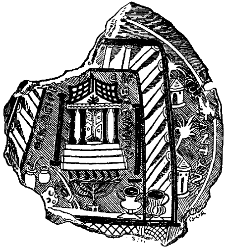
This 3rd-century (AD) glass bowl depicts Solomon's Temple. Boaz and Jachin are the detached black pillars shown on either side of the entrance steps.
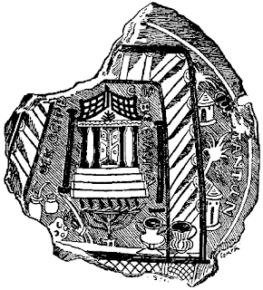

The function and the meaning of these two pillars remains a mystery, a mystery that I will try to solve in this post :)

This is an artist interpretation of the first temple based on the available descriptions. Boaz and Jachin are two dark free standing pillars located on the porch on both sides of the entrance.


The entrance and the porch was located on the eastern side of the temple. This means that the temple entrance and Boaz and Jachin faced the rising sun.


Why is this important for understanding of the meaning of Boaz and Jachin?

In the 2 Chronicles 3:1 we are told that "Solomon built the temple of the LORD in Jerusalem on Mount Moriah, where the LORD had appeared to his father David. It was on the threshing floor of Araunah the Jebusite, the place provided by David..."

So the first temple was built on a threshing floor. A threshing floor probably like this one from Croatia. Threshing floors are platforms where grain seeds were separated from chaff by trampling.

They were normally located on the higher slopes of the hills, or mountains, which were windy, as it was wind that blew away the chaff and helped the extraction of seeds.


Once the threshing floor is constructed it can be used for both threshing and as a solar observatory. What you are actually observing is the shadow made by the central stake or a standing stone. At the sunrise and sunset the shadow will be long enough to cut the circle at the oposite end. This is extremely precise way of marking the sunrise point. 

In 1950, Serbian ethnographer Nenad Janković published a book on folk astronomy called "Astronomija u predanjima, obicajima i umotvorinama Srba" (Astronomy in legends, customs and oral and written tradition of the Serbs). In it he expressed his great surprise at the ability of ordinary illiterate peasants to tell exact date and time without calendars and clocks. Professor Jankovic states that one of the main instruments used for these calendar and time calculations was the threshing floor. By looking at the shadow cast by the stožer, the central pole at sunrise, they were able to tell the date. And by looking at the shadow cast by the stožer, the central pole during the day they were able to tell the time. Threshing floor is a universal solar observatory, which at the same time can tell the date and the time. The main parts of this solar observatory were solar circle and its center, solar pole, stožer. Or if viewed from above, from heaven, the way Sun God would see it, a circle and a dot representing its center, solar pole, stožer. This is the symbol found all over the world and in Egypt it was the symbol of the sun, Ra. The below symbol is usually interpreted to mean sun disc, but I believe that it actually means sun circle, threshing floor and sun cycle observed from the threshing floor.


Greeks called the central solar pole, stožer of the sundial "gnomon" meaning the one which knows. This was because the central stake "new" the time and date. 

According to ethnographic research from the Balkan mountains conducted in the 19th century, threshing floor was the place where all the village meetings, celebrations and ceremonies took place.The ethnographers say that this is because threshing floors were the only flat smooth surfaces big enough to accommodate many people. But was this the only reason? Were threshing floors places where village meetings, celebrations and ceremonies took place because they were considered to be the sacred ground, the place where god lived on earth? I believe so. 

Were threshing floors the mysterious "sacred high places"? I believe so too. 

You can read more about threshing floors and their role in the solar worship rights in my post "Bogovo gumno - god's threshing floor".

In my post "Calendar" I explained why the ancient solar observatories were built and how they were used. The ancient solar observatories were built in order to determine the exact moment of the winter and (or) summer solstice. If you know one or both of these two points on the yearly solar circle, you can create fixed and repeatable lunisolar calendar which is necessary for in order to determine the exact timing of vegetative events during the solar year. 

So how do you determine the exact moment of the winter and (or) summer solstice?

You find a clear flat piece of high ground from which you can observe sunrises and sunsets. The observatory. You stick a pole into the ground to mark the observation spot. Then as the year passes, every morning and every evening you stand next to the observation pole and observe sunrise and sunset. As you are observing the sunrises and sunsets, you notice that the point where sun rises is not the same as the point where sun sets. The sun rises on the left side of the horizon, travels across the sky from left to right and sets at the opposite right side of the horizon. As days pass you realize that the point where the sun rises moves along the horizon. So does the point where the sun sets. You notice that the sunrise point moves during the spring further and further to the left and the sunset point further and further to the right. So the sun needs to travel longer across the sky and the day is longer and longer and hotter and hotter. Then at some point during the summer the sunrise and sunset points start moving in the opposite direction. The sunrise point starts moving to the right and sunset point starts moving to the left. They get closer and closer to each other, so the sun has to travel shorter distance between the sunrise and sunset and the day is shorter and shorter and colder and colder. 


This is extremely important observation if you depend on solar vegetative cycle for your survival. If the length and heat of the day depends on the position of the sunrise and sunset points, then determining how they move becomes imperative. You know that the days when the sunrise and sunset points change the direction of their movements, fall in the middle of the coldest and hottest part of the year. You are of course more interested in the turning point which falls in the middle of the cold dark part of the year. You want to know if, and this was for our ancestors very real IF, and when the sunrise and sunset points will start moving further and further away from each other, because that will mean that the days will start getting longer and hotter again. So you start observing the the horizon and you try to remember where the sun rose yesterday in order to compare it with the sunrise position today. But that is difficult and imprecise. It would be much better if you could mark the points of sunrise every day in some way and then observe the relative position of the sunrise points to the marks. So you decide to use stake, pole as marker. But it is difficult to mark the exact point of sunrise if the horizon is uneven. It would be much easier if the horizon is horizontal, smooth and elevated all around you so that the observation and marking of the sunrise points becomes more precise. So you decide to create an artificial horizontal smooth horizon which will mask the real horizon. You take a long enough rope, tie it to the observation pole and then walk around the observation pole. As you walk you mark a circle with the center in the observation pole.


You then dig a circular trench along the circle and pile up the the dug out earth on the edge of the circle to form the bank. You build a henge like this original earthen henge in Stonehenge. You can read my article about henges here.


Now when the sun rises it will be easy to mark the exact spot of the sunrise with a stake stuck into the elevated earthen bank. Every morning and evening you observe the new position of the sunrise point. If the sun does not rise at the point marked with the yesterday's stake, you move the stake to mark the new position of the sunrise. Then one day in the middle of the winter, the movement of the sunrise point will stop. The sun will rise at the same position behind the yesterday's sunrise stake. That day is the winter turning point, the winter solstice, the shortest day of the year. You mark this point with the permanent taller stake. So when the sun again rises behind this tall sunrise stake you will know that the winter turning point, the winter solstice, the shortest day has arrived again. You do the same for the day when the sun rises twice behind the same stake in the summer. That day is the summer turning point, the summer solstice, the longest day of the year. You mark this point with the permanent taller stake too. So when the sun again rises behind this tall sunrise stake you will know that the summer turning point, the summer solstice, the longest day has arrived again. 


Do you see how much the above henge looks like a threshing floor? If you were using threshing floor as a solar observatory, and if you marked the solstice points with two sticks your threshing floor would look like this:


Now if you know the position of the winter and summer solstice, the three stakes, the central stake, and the two solstice stakes can be used to determine the position of the true east. 


Which could be very useful if, for instance, you were building a temple that you wanted to orient towards the east. By the way do you know that to orient literally means to turn east?

So we have two sticks, stuck at the edge of the threshing floor, the ancient solar observatory, on top of which the first temple was built. Marking the sun's turning points on the horizon, one for winter solstice, the other for summer solstice. Between is east, the area of the horizon where sun rises. Two sticks mark the entrance into the house of Sun, the house of God. The sun gate...Right in the middle of this due east, the direction towards which the ancient Hebrew temple door was oriented, to welcome God (sun) in... Hence two pillars, Boaz and Joktan...

Knowing this, I don't think that the decision to build the first temple on a threshing floor was accidental. Threshing floors and other solar observatories were holy places for sun worshipers. And if the sun worshipers wanted to build a temple dedicated to the sun god, then building it on top of a threshing floor and orienting it towards the east and marking the points of the two solstices with two prominent free standing columns would be very logical thing to do indeed. 

But wait, am I saying that the first temple was dedicated to the sun god? Is there any indication that that this could have been the case? Actually yes...But more about this in my next post. 

Sunday, 25 June 2017

Chimera

This is an electrum stater from the ancient city of Kyzikos, Mysia, circa 550-500 BC. It has a chimera above a tuna fish which was the civic badge of Kyzikos. The reverse is a quadripartite incuse square, an abstract representation of swastika, the symbol of sun's fire. 


Chimera is a monster of which a brief description in Homer’s Iliad is the earliest surviving literary reference. Homer, who wrote during late 8th, early 7th century BC, depicts it as "a thing of immortal make, not human, lion-fronted and snake behind, a goat in the middle, and snorting out the breath of the terrible flame of bright fire". It was the offspring of Typhon (last son of Gaia, fathered by Tartarus)

This Etruscan (Rascian) bronze, dated to 400 BC, is known as "Chimera of Arezzo". 


You can find high resolution image here.

The sculpture has an inscription reading "Tinia" on its front right leg. Tinia (also Tin, Tinh, Tins or Tina) was the god of the sky and the highest god in Etruscan mythology, equivalent to the Roman Jupiter and the Greek Zeus.

Interestingly in Irish the word "tine" means "fire", and in Serbian the word "tinja" means "smoldering"...

What does this have to do with Chimera? Well Chimera "snorts out the breath of the terrible flame of bright fire". And she does it through the mouth of a lion. Now, as I already explained in my post "Two crosses",  the hottest part of the year in the northern Europe falls at the end of Summer and the Beginning of Autumn. In South Slavic tradition this period is called Kresovi meaning Fires. These are the days of wild fires and droughts. And interestingly this period is on the Zodiac circle represented by the symbol Leo, Lion. Lion which "snorts out the breath of the terrible flame of bright fire". 

Now in my last post "You will trample the great lion and the serpent" I talked about the solar symbolism hidden in Psalm 91 (Greek numbering: Psalm 90), also known as the Psalm of Protection, and the image known as "Christ treading on the beasts" which is based on this psalm. In this post I explained why snake is a symbol of the beginning of the summer and why lion is the symbol of the end of the summer. 

Summer starts on the 6th of May, Day of Jarilo, Beltine. Jarilo represents the sun's heat, symbolized by the snake and the dragon. Funnily Jarilo was Christianized into St George, the Dragon killer :) In Serbia, St Jeremija who is celebrated at the beginning of May is known as the Snake Saint. His day (1st of May according to the Julian calendar, 14th of May according to the Gregorian calendar) is the time when people perform magic ceremonies for protection from snakes...Interesting both names Jarilo and J(a)eremija have the root "jar" meaning "bright heat".

Summer ends on the 2nd of August, Day of Perun, Lughnasadh. Day of Perun falls in the middle of the Leo (Lion) zodiac sign


Knowing this it is easy to understand why Chimera has a snake tail and a fire breathing lion head. Summer starts in the sign of Snake and ends in the sign of Lion. The heat increases during this period until it turns into "terrible flame of bright fire". 

What is interesting is that in Serbian mythology the 2nd of August, the point on the solar circle which marks the end of Summer and the beginning of Autumn, the hottest part of the year, is also the day of Perun, the Slavic Thunder god. In Irish mythology this day is known as Lughnasadh, the day of Lugh, the Celtic thunder god. Why is the day of the thunder god in the middle of the hottest period of the year? Because right after the 2nd of August, the day of the maximum heat, the sun starts cooling down. The first Autumn thunderstorms arrive. Thunder god defeats the dragon. As I already explained in my post "Three suns", dragon is in Slavic mythology, with snake, symbol of sun's heat. The sun's heat which causes drought. The sun's heat that steals the "waters of heaven", rain. Once the Thunder god kills the dragon, once the sun's heat starts dissipating, the waters of heaven which the dragon stole are released, and the rains return...This is why the name of the sky god is inscribed on the Chimera's front right leg. 

But what about the goat's head that protrudes from the lion's back?

In my post "Goat" I talked about the symbolism of ibex goat and why is the Capricorn zodiac sign where it is on the solar circle. 

Now here is the important bit:

Alpine ibex mating season starts in December, and ends in January typically lasting around six weeks. 

Bezoar Ibex mating season starts in November and ends in January. 

Right in the middle of the mating periods of both Alpine and Bezoar ibex is Winter Solstice, 21st of December. And the day after the winter solstice is the beginning of the Capricorn (goat) period, which last from December 22 – January 20...


Have a look at this image. This is solar circle, with the beginning (snake), the middle (summer solstice) and the end (lion) of summer marked at the bottom of the Zodiac circle, and the middle of winter (winter solstice) marked at the top of the circle.


This is our Chimera. 


Chimera with the body with snake tail (beginning of summer), lion head (the end of summer) which all together represents summer. And with the ibex goat head on it's back, which represents the winter solstice.

And so it turns out that Chimera is not a monster, but a symbol of the sun. More precisely Chimera is the symbol of the solar yearly cycle. 

Interesting don't you think?

Monday, 22 May 2017

He must increase and I must decrease


In John's Testimony about Jesus, St John the baptist says this about Jesus:

"He must increase and I must decrease."

What does this statement mean?

John the Baptist was an itinerant preacher in the early first century AD. Most scholars agree that John baptized Jesus. Scholars generally believe Jesus was a follower or disciple of John and several New Testament accounts report that some of Jesus' early followers had previously been followers of John. Some scholars maintain that John was influenced by the semi-ascetic Essenes...

But the connection between John the Baptist and Jesus is much much deeper: They were cousins born exactly six months apart. 

At the Annunciation, when the angel Gabriel appeared to the Virgin Mary to inform her that she would conceive of the Holy Ghost, he also informed her that Elizabeth, her cousin, was already six months pregnant with John the Baptist (Luke 1:36). 

Considering that Jesus was born on Christmas day, the 25th of December, John the Baptist, who was conceived six months earlier was born six months earlier, on the 24th of June, which is celebrated as the Nativity of John the Baptist. 

The Nativity of John the Baptist is one of the oldest festivals of the Christian church, being listed as a principal festival in 506 when it was celebrated in the same way as the Nativity of Jesus: it was a day of rest and was celebrated with three Masses: a vigil, at dawn, and at midday.

Now Christ was born on the 25th of December. At the time of the birth of Jesus, 25th of December was known as Brumalia. Brumalia was an ancient Roman, winter solstice festival. The name Brumalia comes from "brvma", [ˈbruːma] meaning "Winter solstice".

Brumalia was always celebrated on VIII Kal. Ian. (Servius A. 7.720). The eighth day before the Kalends of January was always December 25th in the Julian calendar, because December always had 31 days.

John the Baptist, being born exactly six months earlier, was born on the 24th of June. If at the time of the birth of Jesus, 25th of December was the winter solstice day, 24th of June, the date exactly six months away must have been the day of the summer solstice. So John the Baptist was born on the day of the summer solstice. 

So Christ was born on the day of the Winter solstice, the shortest day, after which days start getting longer. And John the Baptist was born on the day of the Summer solstice, the longest day, after which days start getting shorter. 

And so finally here is my proposed explanation for John's statement about Jesus: "He must increase and I must decrease". It is the light of the sun, the duration of the day that increases from winter solstice (birth of Jesus) to summer solstice, and decreases from summer solstice (birth of John the baptist) to winter solstice. 

Is this solar symbolism a coincidence?


Monday, 25 July 2016

Two crosses

This is Sun's sunlight cross. It marks the transitional points on the sunlight cycle in the northern hemisphere:

1. Winter solstice - the shortest day and the longest night
2. Spring equinox - the equal day and night
3. Summer solstice - the longest day and shortest night
4. Autumn equinox - the equal day and night


This is Earth's, climate, vegetation cross. It marks the transitional points of the climatic, vegetative cycle in the northern hemisphere:

Celtic calendar:

1. Imbolc- the beginning of the spring
2. Bealtaine - the beginning of the summer
3. Lughnasa - the beginning of the autumn
4. Samhain - the beginning of the winter


Serbian calendar:

1. St Sava - the beginning of the spring
2. St George - the beginning of the summer
3. St Ilija - the beginning of the autumn
4. St Mitar - the beginning of the winter


As you can see the sun cross and earth cross are out of sync. The earth cross is rotated forward by 45 degrees and the earth circle cardinal points fall right in between the sun circle cardinal points. This is because the earth climatic, vegetative cycle lags behind the solar cycle. 

Winter solstice (21st of December) is the the shortest day. So we would expect that this is also the coldest day. We would also expect that from that day on, as the days start getting longer, the days also start getting warmer. But as we all know, this is not the case. The days do get longer, but the earth continues to cool. It is only at the beginning of February that we start seeing the first signs of the earth warming up. This is why the beginning of spring is at the beginning of February (Imbolc, St Sava (14th of January, but probably a replacement for the old Imbolc which is celebrated on the 1st of February)). The actual mid point is 4th of February. Which falls right in the middle of Aquarius (21 January – 19 February).

Spring equinox (21st of March) is the moment when the day is as long as night. From that day the days are longer than nights. We would expect that this would mark the beginning of the summer. But the real heat does not start until the beginning of May. This is why the beginning of summer is at the beginning of May (Bealtaine, which is today celebrated on the 1st of May, but there are indications that it was once celebrated on the 6th of May. Here we find St George's day celebrated on the 23 of April, probably replacement for old Bealtaine). The actual mid point is 6th of May. Which falls right in the middle of Taurus (21 April – 21 May).

Summer solstice (21st of June) is the longest day of the year. We would expect that this would also be the hottest day of the year. We would also expect that from that day on, as the days get shorter, the days also get colder. But again as we all know, that is not the case. The days do get shorter, but earth continues to warm. It is only at the beginning of August that we start seeing first sings of earth cooling down. This is why the beginning of autumn is at the beginning of August (Lughnasa which is today celebrated on the 1st of August but was once probably celebrated on the, 2nd of August. Here we find St Ilija's day celebrated on the 20th of July, probably replacement for old Lughnasa). The actual mid point is 2nd of August. Which falls right in the middle of Leo (23 July – 22 August).

Autumn equinox (21st of September) is the moment when the day is as long as night. From that day the days are shorter than nights. We would expect that this would mark the beginning of the winter. But the real cold does not start until the beginning of Novermber. This is why the beginning of winter is at the beginning of November (Samhain, St Mitar (26th of October, but probably the replacement for the old Samhain which is celebrated on the 31st of October)). The actual mid point is 5th of November. Which falls right in the middle of Eagle (Scorpio) (24 October – 22 November).

This last drawing is the diagram of transformation of Sun's sunlight cycle into Earth's climatic, vegetative cycle. 

The Sun cross transitions into the Earth cross. This transition is governed by the slow accumulation and release of the heat which is transferred from the Sun to the Earth through sunlight...

Does this golden cross which symbolizes this transition of light into heat into life energy remind you of anything?


This is the never ending wheel of life...

PS: It seems that AngloSaxons had the same rotated vegetative calendar...

Friday, 27 March 2015

Blagotin

In the 6th millennium bc, in Serbia we find Vinča culture. I believe that everyone reading this post have heard of the Vinča culture, the culture that invented metallurgy, alphabet. Slightly earlier, at the end of the 7th millennium bc we find on the same territory of Central Serbia, the Blagotin culture. I can bet that most people reading this post have never heard of the Blagotin culture. 

Let me tell you a story about Blagotin culture.


Archaeological locality Blagotin got its name after the hill called "Mali Blagotin" under which it is located. Mali Blagotin is located in the heart of Serbia, in an area known as Šumadija. The region is characterized by a southern variant of the Central European temperate climatic regime. The site is located on the northern outskirts of the village of Poljna, 12 km north of the slightly larger village of Velika Drenova, and about 50 km northeast of the town of Trstenik (in the county or opština of Trstenik). It is on a gently sloping terrace, above an incised stream valley at the base of a mountain. The surface of the site was entirely cultivated during the period of field research. Blagotin is a multi-period and strati-graphically complex site. It was initially inhabited during the Early Neolithic (Starčevo culture, ca. 6100–5100 B.C.). Recent radiocarbon dates place it among the earliest sites in the Starčevo culture – ca. 6100 B.C.

The Starčevo culture, sometimes included within a larger grouping known as the Starčevo–Kőrös–Criş culture, is an archaeological culture of Southeastern Europe.The Starčevo culture covered sizable area that included most of present-day Serbia and Montenegro, as well as parts of Bosnia and Herzegovina, Croatia, Hungary, and the Republic of Macedonia.


Blagogin site was then reoccupied during the Eneolithic (Baden-Kostolac culture, ca. 3300–2500 B.C.), and then occupied again during the Early Iron Age (Halstatt culture, ca. 1000–700 B.C.). It was not occupied again until modern times. Here is where the Blagotin site is on the map of the Balkans.


The reason why people kept coming back to Blagotin and settling there for thousands of years is that Blagotin area as well as central Serbia as a whole is an ideal place for subsistence farming combined with hunting and gathering. Central Serbia consists of a series of small to medium alluvial river valley planes formed by river Morava and its tributaries, surrounded by rolling hills and medium size mountains. These alluvial valley plains were created by the deposition of sediment over a long period of time by one or more rivers and streams coming from highland regions, from which alluvial soil forms. These rivers still flow through these valleys and form floodplains. The floodplains are the smaller area over which the rivers flood at a particular period of time, like in the spring during the snow melt, whereas the alluvial plain is the larger area representing the region over which the floodplains have shifted over geological time. Alluvial plains and flood plains are very very fertile and very easy to work with primitive agricultural tools such as hand plows and adzes made out of antler like this one:


Or wood and stone ones like these ones:


It is in the alluvial and flood plains that grain agriculture developed and flourished in the early Neolithic times. This is the list of main alluvial and flood plains in Asia and North Africa.


Po valley plain
Punjab alluvial plain
Indo-Gangetic plain
Tigris–Euphrates plain
Nile valley
Yangtze valley

You can see that these alluvial flood plains are the exact places where the early farmers settled and formed the first agricultural civilizations. The soil is sandy and therefore easy to work, it is rich and gives high yields, and it is regularly enriched with new flood deposits preventing soil depletion, which was the main problem for early farmers.

In Central Europe we find the Lower Danube-Sava-Morava-Tisa Central European alluvial flood plains. And this is exactly the place where we find the most advanced Early European Neolithic agricultural civilizations.

This is the map showing Blagotin hill, an Island in the middle of an area of rolling hills and small river valleys.


16 kilometers to the south from the Blagotin hill is Zapadna Morava river valley. This is what this river valley looked like during last year's floods. 


The valley was flooded after a sudden snow melt combined with heavy rain and saturated ground from previous rains. These types of floods are today very rare because the river now has flood defenses built along its banks. In the distant past this kind of flooding of the river valley was much more frequent and kept the valley floor extremely fertile.

This is what this river valley looks like on a nice dry sunny day.


If you look at the above picture of the river valley, you can see that the bottom of the valley is completely flat, a sign of an alluvial deposits, the prime agricultural land. From the Zapadna Morava river, the therein towards Blagotin hill is a slightly raised plateau consisting of rolling hills and small flat old alluvial river valleys. It is called Poljna plain. Poljna literally means a plain. 

This is what I am talking about. This is Poljna plain which lies between Blagotin hill and Zapadna Morava river.


This is the exact location of Blagotin site just beneath the Blagotin hill at the edge of Poljna plain:


The hills surrounding these river valleys used to be covered with mixed oak forests. The name of the region "Šumadija" means the land of forests. These forests were full of oaks, hazels, beaches and therefore full of edible nuts, acorns and beach nuts as well as mushrooms and berries and other wild fruit like wild apples, pears and cherries. All these wild foods were found in deposits belonging to the early neolithic cultures in the Balkans. The river itself is full of fish even today and it must have been teaming with fish in Neolithic times. The whole area is also full of wild birds and animals even today, and in the Neolithic times it must have been an ideal hunting ground.

At the end of the 7th millennium, the Neolithic farmers arriving from the Levant crossed the mountains dividing the Mediterranean climatic zone and the Semi Continental Balkan climatic zone and found themselves in these river valleys. There they had to learn how to adapt their agricultural techniques to this new climate. I would say that that was a quite a big challenge which took a good while. The neolithic farmers which arrived from Levant stayed in Serbia for almost 1000 years before moving further north. But once they started this move north it was very quick and only 500 years later we find them on the shores of Holland. During the time when agriculture was still developing and adapting to the European climate, and when people still heavily depended on hunting and gathering, the area around Blagotin, with its abundance of wild food would have been and ideal place to settle.

How good Blagotin is for living is actually reflected in its name. The Serbian word "blag" means gentle, sweet, but also domesticated, cattle and treasure. The ending "tin, ten, tan, din, den, dan" are quite common endings found in village and town names in Serbia and correspond to the Irish "dun" meaning enclosure, village, town, place....The name Blagotin literally means gentle, cultivated, rich place good for living...

So the Neolithic farmers arrived to Blagotin and built a settlement. But not just any settlement. The settlement covers the area between one and two hectares which would classify it as a medium size settlement. But it is the structure of the settlement, its layout, which sets it apart from all the other settlements of its time. Blagotin settlement type was completely different from both Levantine and Southern Balkan and Central and Northern European settlement types.

In the work on spatial organization of the site entitled: "The spatial organization of Early Neolithic settlements in temperate southeastern Europe: a view from Blagotin, Serbia." published by Haskel J. Greenfeld and Tina Jongsma, from the University of Manitoba point to a very important difference between the spatial organisation of Blagotin settlement compared to all the other contemporary early neolithic settlements:

In Levant and the southern or Mediterranean half of the Balkan Peninsula (Greece, Macedonia, and southern Bulgaria), most early neolithic settlements are represented by tell-like deposits, with rectilinear above-ground and free-standing architecture.

Very different kinds of archaeological deposits are found in the major Early Neolithic archaeological cultures of central Europe. Most sites are very shallow, with little if any vertical superposition of deposits. They are largely characterized by laterally displaced deposits. The architectural forms in LBK sites tend to be very rectangular surface structures. Characteristically, they are extremely long and easily identifiable by the distribution of post molds in the soil. In LBK sites where settlement has been short term and the distribution of features is visible, long houses are placed parallel to each other, although it is difficult to perceive the presence of any clear rows.

In the northern or temperate half of the Balkan peninsula and extending across the rest of southeastern Europe, early neolithic tell-like settlements and long house settlements are almost non-existent. Instead, most sites appear to be composed of laterally displaced horizontal deposits associated with pit house deposits. The early neolithic Starčevo culture site of Blagotin is one such pit house site. Two types of pit houses are distinguishable.

A smaller and shallower set of pit houses, 3 m wide and 6 m long, is distributed in a circle around a large open space. These smaller houses are arranged along radial streets which all lead to the central square. According to the professor Stanković there were 100 of these houses which means that the estimated population of Blagotin was around 500 people.

The second larger and deeper pit, approximately 10 m wide and 8 m long, is found at the center of the large open space, central square. The central house is clearly very different from those surrounding it and based on its design and the deposits found in it, it is undoubtedly a sacred place, a temple. This make Blagotin temple the oldest purposely built temple in Europe and the Second (or third) oldest temple in the world, after Gobelki Tepe (and possibly some Çatalhöyük dwellings if they can be classified as temples).

The oldest known temple in the world is that at Göbekli Tepe in southeastern Turkey which is 11,500 years old and is decorated with reliefs and pictograms of various plants and animals thought to represent the gods of that place. The temple is an extraordinary building of the Neolithic era with T-shaped pillars and engravings which have yet to be completely understood. The design of the temple, however, with a large room toward the front (possibly for public functions) is recognized in later temples from other cultures.


Çatalhöyük, the largest and best-preserved Neolithic site found to date, was composed entirely of domestic buildings, with no obvious public buildings. However some of the larger ones have rather ornate murals, the purpose of some rooms remain unclear. Vivid murals and figurines are found throughout the settlement, on interior and exterior walls. Distinctive clay figurines of women, notably the Seated Woman of Çatalhöyük have been found in the upper levels of the site. Although no identifiable temples have been found, the graves, murals, and figurines suggest that the people of Çatalhöyük had a religion rich in symbols. Rooms with concentrations of these items may have been shrines or public meeting areas. 


The pits are all shaped in the form of an ellipse or rough trapezoid. The settlement structure looks something like this:


There is little detailed information on the spatial distribution of features within Starčevo-Körös-Criş sites. Only a few sites have been spatially excavated. These enable us to better understand the internal structure of these sites and to interpret areas of activities. At each of these sites, almost all of the structures excavated were semi subterranean. And it seems that they all follow the same radial spatial organization of the settlement found in Blagotin. In the Foeni-Salaş site five small structures were found distributed in  semicircle around a larger structure. The  distance between each of the small structures was more or less the same (about 20 m), and the distance between the central and peripheral structures was about 10 m. Such a distribution of Early Neolithic features was found long before this, albeit it was not recognized as such. Vasić in his early excavations in the basal levels at Vinča found a similar distribution of Starčevo pit features – a large central pit house surrounded by an open space of about 10 m and a ring of peripheral smaller pit houses. This shows that at Blagotin we see emergence of a new culture previously not seen in Evroasia, the Starčevo culture which should really be called Blagotin culture, and the Culture which will later become the seed from which the famous metallurgical Vinča culture will develop.

Interestingly this type of settlements continue to be built in Central Europe until the medieval times by Slavic people.

Early Slavic settlements were no larger than 0.5 to 2 hectares. Settlements were often temporary, perhaps a reflection of the itinerant form agriculture they practiced. Settlements were often located on river terraces. The largest proportion of settlement features were the sunken buildings, called Grubenhäuser in German, or poluzemlianki in Russian, zemunice in Serbian. They were erected over a rectangular pit and varied from four to twenty square meters of floor area, which could accommodate a typical nuclear family. Each house contained a stone or clay oven in one of the corners, a defining feature of the dwellings throughout Eastern Europe. On average, each settlement consisted of fifty to seventy individuals. Settlements were structured in specific manner; there was a central, open area which served as a "communal front" where communal activities and ceremonies were conducted. The settlement was polarized, divided into a production zone and settlement zone.

In Blagotin we find several overlapping phases of the settlement development. The earliest feature of the site is a 2,5 meter deep sacrificial pit, around which the temple was later built. At the bottom of the pit archaeologists have found a ritually broken deer scull with separated mandibles positioned at a certain angle. 


Official theory is that this seems to connect the Starčevo culture to the much older Paleolithic deer cultures of Europe from the time before the last Ice Age. This makes Starčevo culture a link between the Paleolithic Mesolithic Hunter gatherer cultures and Neolithic agrarian cultures. This could also be an indicator of the mixing between the local European hunter gatherers and the incoming Levantine farmers. It is possible that the Blagotin culture is a product of this mix. 

Deer is also a very important symbol found in in many agrarian cultures which come after Starčevo cultures. 

Why deer? The Deer is a symbol of the sun, summer, repeating seasons, growth an waning and eternal life. In the Balkans it is still believed that the deer is an animal which guides the dead to the underworld, that it is an animal which can cross the boundary between the worlds. Like the sun which spends the day in our world and the night in the underworld.

But it was probably deer which lead hunter gatherers to the wild grain in the first place. It was hunters observing deer eating wild grain who first got the idea to try to eat it themselves. And believe or not, it was deer mandibles which were used as the first sickles for harvesting first wild and later domesticated grain. So placing sickles at the bottom of the sacrificial pit at the centre of the grain farmer's temple suddenly makes a lot of sense. And this also explains why deer is found as a symbol in many agrarian cultures. 

I talked about the development of sickles from deer mandibles in my post "Ri - to cut with something toothed".

A thick ash deposits were found in the pit showing that the offerings were burned, that the cult was in a way related to fire. This is another indicator that the cult practiced in Blagotin was a sky cult, and that the deity worshiped was the sun, in his fiery form. In the ash, the remains of a human infant were interred. The remains from the pit also included extremely large numbers of the bones of young female animals. This points to the cult being not just solar cult but also a fertility cult, which is what you would expect an agricultural cult to be.

The sacrificial pit was surrounded with a zigzag line. There is no exact drawing of the pit but it probably looked like this:


Looks familiar? Looks like the sun? This shows that the zigzag line later found in  Vinča  deposits is closely connected with the cult and has a religious significance. And we know exactly what this zigzag line means. The zigzag line is a symbol of the solar ecliptic. The solar ecliptic is the apparent path of the Sun on the celestial sphere. The solar ecliptic is the line that defines the seasons, that defines the climate, that governs agriculture. 


For people who arrive from the Levant, European winters must have been quite a shock. The dying of the sun's fire must have been a major cause for concern and all necessary steps had to be taken to ensure that it gets rekindled every spring. Including sacrifices....Were the sacrifices which were made in the Blagotin temple made to ensure that the Sun's fire gets rekindled again? Were they performed at maybe a winter solstice?

If you are a farmer, the further north you go from the equator the more important it becomes to understand the behavior of the sun. Which eventually lead to the development of the solar astronomy and solar agricultural cults. Is it possible that in Blagotin we see the emergence of the solar astronomy and the emergence of the Solar cults? Is Blagotin temple not just the first temple but also the first solar temple? I believe so and I believe that the the proof for this lies in the temple itself, or more precisely its orientation.

The temple went through 7 phases of development. Through all of these phases the temple retained the same sacred altar space which was built around the sacrificial pit. The profane part of the temple undertook several structural changes BUT THE TEMPLE AS A WHOLE WAS ALWAYS ORIENTED EXACTLY NORTH - SOUTH. 

There are three ways to orient a building exactly north south. One way is to use a compass to determine the exact north. In the 7th millennium bc, this was highly unlikely to have happened. The other two ways are:

1. Find the north star and orient your building to it. For this you need to know what the north star is and that it is a static star pointing north, which means that you need to be versed in star astronomy.

2. Determine the exact points where the sun rises on the days of the winter and summer solstice. Bisect the arch between these two points into half. This will determine the point where the sun will rise on the equinoxes, the true east. Draw a line pointing east - west 
Draw an orthogonal line which will point north - south Align your temple with this line...To be able the align their temple north - south, you need to know a lot about the sun's apparent movement in the sky which means that you need to be versed in solar astronomy. 

In order to be able to orient their temple north - south, he people from Blagotin needed to be be able to do one of the above, which would mean that the people from Blagotin were not just farmers but accomplished astronomers and mathematicians. Probably the first people in the world to create a temple aligned with solar cardinal points.


Originally it was shaped as a mushroom (penis) where the semicircular part had a bench build along its its edge where people worshiping in the temple, could sit. Later on the bench disappears and instead of it we find two high thrones. People sitting on these thrones would have looked directly towards the altar and the south. Then the mushroom (penis) shaped area was remodeled in such a way that the whole temple including both the sacred and the profane area together resembles a Greek letter theta. Eventually the whole temple was completely changed. The profane part was covered with a thick layer of daub and a new a long narrow building oriented north - south was constructed in place of the old temple. The altar was in the center of the new building and flanking the south entrance were two unusual large (30 cm high) figurines which looked like this.


They had over emphasized gluts stylized short legs and according to the early interpretation offered by the archaeologists, stylized deer head. This means that the sculpture consisted of the female principle (lower part of female body) extending into the male principle (deer head the top part of the body). The "goddesses" were found "lying on their faces" and I believe that this gives us an important clue for deciphering their meaning. Recently archaeologists made copies of these goddess figurines using the same clay from which the original figurines were made. Then they fired the figurines using the reconstructed early neolithic oven.


On the last picture, the goddesses were "laid on their faces". And here the meaning of these goddesses becomes clear. They are half women in the "kneeling, on all four" position, ready to be mounted, penetrated and fertilized, like any other female animal, from behind. So the bottom part is not just a woman but a female of any domestic kind which we want to fertilize in order to produce offspring. In this position the upper part of the body, the male part, penetrates the earth, like a plow. If anyone wanted to make a symbol that links fertility and farming (grain growing and cattle razing), they couldn't have made a better one. These figurines are probably the first fertility idols directly linked to agriculture. They create symbolic equalization between a plow and a penis and between plowing and copulating, between sex and working the land.

These figurines are not the only important objects found on Blagotin site.

All of the excavated pit houses contained extraordinarily large amount of ceramic fragments and whole ceramic vessels and figurines. The biggest number of ceramic fragments was found in the temple which shows that the ceramic artifacts were brought to the temple as offerings and were possibly ceremonially broken inside the temple. On only 30 square meters which have been excavated so far, archaeologists have found 16,000 ceramic fragments. Ceramic vessels found in the pit houses range from ordinary domestic utensils to exquisitely ornate ceremonial vessels.


One of the ceramic vessels found on the site is an unusual cross shaped bowl shown here with a ceramic altar and  ceramic votive grains of wheat also found on the site.


There are two articles published about the pottery from Blagotin. A use analysis for the pottery from one of the houses from the site can be found in the article entitled: "Beginnings - New Research in the Appearanceof the Neolithic between Northwest Anatoliaand the Carpathian Basin". A possibility of early beer production was explored in the article entitled "Non-abrasive Pottery Surface Attrition: Blagotin Evidence". Both were published by Jasna Vuković from Belgrade university. 

Apart from the ceramic vessels  archaeologist have found many ceramic altars like the one on the above picture or this one:


A very important  find is a very large number of clay models of grains of wheat,  which you can see on the above picture with the cross shaped vessel and the altar. These clay seeds were left in the temple as votive offerings. This confirms that the people who lived in Blagotin were grain farmers and that their cult was grain fertility cult. These clay grain sees are found on other Starčevo culture sites but never in this number.


One of the clay seed models has engraved the plan of the village with the temple as the central object. The plan closely corresponds to the actual layout of the part of the Blagotin village.


This is the earliest known town map in Europe and possibly the oldest map in the world.  Until very recently this was undobtedly true. The two next oldest maps were the "Ga-Sur at Nuzi" map and "Nippur" map.
 
The Ga-Sur at Nuzi map is a Babylonian clay tablet that was unearthed in 1930 at the excavated ruined city of Ga-Sur at Nuzi [Yorghan Tepe], near the towns of Harran and Kirkuk, 200 miles north of the site of Babylon [present-day Iraq]. Small enough to fit in the palm of your hand (7.6 x 6.8 cm), most authorities place the the date of this map-tablet from the dynasty of Sargon of Akkad (2,300-2,500 B.C.); although, again, there is the conflicting date offered by the distinguished Leo Bagrow of the Agade Period (3,800 B.C.). The surface of the tablet is inscribed with a map of a district bounded by two ranges of hills and bisected by a water-course. This particular tablet is drawn with cuneiform characters and stylized symbols impressed, or scratched, on the clay. Inscriptions identify some features and places. In the center the area of a plot of land is specified as 354 iku [about 12 hectares], and its owner is named Azala. None of the names of other places can be understood except the one in the bottom left comer. This is Mashkan-dur-ibla, a place mentioned in the texts from Nuzi as Durubla. By the name, the map is identified as of a region near present-day Yorghan Tepe (Ga-Sur at the time, the name Nuzia 1,000 years later), although the exact location is still unknown.


The Nippur map is a fragment of a clay tablet which contains a city map, which was dated to 1500 BC. The clay tablet depicts the temple of Enlil, a city park, the city wall including its gates, along with a canal and the river Euphrates. The individual objects on this map were already labelled, in a Sumerian cuneiform.


Both of these maps are much younger than the Blagotin grain map. However we now have a close competition for the oldest map in the world between the Blagotin grain map and the Çatalhöyük wall map. During the excavation of Çatalhöyük in Anatolia a wall painting was uncovered that is approximately nine feet long and has an in situ radiocarbon date of 6,200 + 97 B.C. It is believed that the map depicts a town plan, matching Çatalhöyük itself, showing the congested "beehive" design of the settlement and displaying a total of some 80 buildings. In the foreground is a town arising in graded terraces closely packed with rectangular houses. Behind the town an erupting volcano is illustrated, its sides covered with incandescent volcanic bombs rolling down the slopes of the mountain. Others are thrown from the erupting cone above which hovers a cloud of smoke and ashes.


However 🙂 the winner of the is this: a line incision on a mammoth tusk found in Mezhirichi in the Ukraine, and dated to 12,000-11,000 BC. This is interpreted as being a river with dwellings on the banks, and fishing nets in the river.


Another important type of artifacts found in Blagotin are amulets.


In her work "The Blagotin amulets and their place in the early Neolithic of the central Balkans" Jasna Vukovic says:


On this graph you can see the distribution of these amulets. Divostin the site with the second highest number of amulets is the site closest to Blagotin. The further away you go from Blagotin, the fewer amulets you find. 


Do these amulets remind anyone of the Gobelki Tepe columns? Did part of the Gobelki Tepe people and religion find its way to Blagotin?

Another large group of objects found in Blagotin are votive models of domestic animals, which were deposited in the temple as offerings. This means that the people living in Blagotin were both grain farmers and herders.


What is very interesting is that we find the same types of domesticated animals figurines in Catalhoyuk at the roughtly the same time. Nearly 2,000 figures have been unearthed at Catalhoyuk. They were dated to about 7000 BC. The majority are representations of cattle or sheep and goats.Like these ones:


Does this suggest that the people who settled in Blagotin came from Catalhoyuk? Or that they were culturally connected with the people from Catalhoyuk?

In Blagotin, archaeologists also found grinding stones. Unfortunately I don't have any pictures of these grinding stones but they probably looked like this one.


Flotation technique also yielded a lot of grain seeds which were extremely big for that period and were in size comparable to the modern sorts of wheat. Antler plows and other neolithic agricultural tools were also found on the site. After taking into the account all the evidence from the site archaeologists working on the site concluded that the people living in Blagotin probably grew enough good quality grains to make wheat bread. 

Archaeologists have also found other bone and stone tools and blades:


Archaeologists also found a lot of jewelry on the site like these necklaces and bracelets:


Some jewelry found in the temple resembles ones found in the Transilvania. Some other material came from Kosovo and Black Sea coast. This suggests that Blagotin was an important regional (Balkan) and maybe even Central European religious center where people came at certain part of the year to celebrate and pray. Maybe at winter solstice. Or at harvest time.

And so this is Blagotin, probably the most important archaeological site you have never heard of. The site where European Neolithic agricultural society was born. The site where we find the oldest temple in Europe and the second (or the third depending how you count) oldest temple in the world. The site where we find the oldest evidence of the complex astronomical and mathematical knowledge required to determine solstices and equinoxes and align the temple to cardinal points. The site where we find first definite evidence of the development of the solar agricultural fertility cult. The site where we find the oldest town map in Europe and the oldest (or the second depending how you count) town map in the world. 

The Blagotin site was discovered by  Dr Svetozar „Nani“ Stanković just before the start of the Yugoslav civil war in 1991. This is the man himself.


The excavations were then continued until 1995 as a joint venture between the University of Belgrade (Serbia) and the University of Manitoba (Canada). Dr Svetozar „Nani“ Stanković (1948 - 1996) who lead the excavation, died in 1996 and the whole archaeological site was closed and forgotten??? Only 2.5% of the locality has been excavated so far. The site is not protected by Serbian government or by UNESCO. The goddess figurines are locked in the depot of the Belgrade University...

The only two papers written about the site which are written in Serbian and are which are available on the internet are "1992b Arheološka istraživanja višeslojnog praistorijskog lokaliteta Blagotin u selu Poljna istraživanja 1991 godine". "Systematic surface collection from Blagotin". 

Believe or not the best information about the Blagotin site is contained in this three part documentary made in 1993, which features interview with the late Dr Svetozar „Nani“ Stanković.

Blagotin Documentary Part 1
Blagotin Documentary Part2
Blagotin Documentary Part 3

I extracted all the relevant information in this article. There is no point looking on the net for more info. This is it. This is all there is...Sad. 

There are talks about reopening of the excavation on the site this year, 20 years after the site was forgotten.