Showing posts with label Europe. Show all posts

Monday, 15 February 2016

Alps

The Alps (Italian: Alpi; French: Alpes; German: Alpen; Slovene: Alpe) are the highest and most extensive mountain range system that lies entirely in Europe, stretching approximately 1,200 kilometers (750 mi) across eight Alpine countries: Austria, France, Germany, Italy, Liechtenstein, Monaco, Switzerland and Slovenia. 


But these are not the only Alps in Europe. In The Balkans we find Dinaric mountains known also as Dinaric Alps. This mountain range stretches along the Eastern Adriatic coast across Albania, Serbia, Montenegro, Bosnia, Croatia and Slovenia. The highest peaks of the whole range are in the southern end which lies in Montenegro, Serbia and Albania. 


The English word alps comes from the Latin alpes which comes from Latin albus ‎meaning white. Latin albus, is said to come from Proto-Italic *alβos meaning white.

The official etymology says that we don't really know where the original word comes from.

Basically we have two theories.

First theory proposes a Proto-Indo-European root for the word Alps. It says that the Proto-Italic *alβos is derived from Proto-Indo-European *h₂élbʰos, *álbʰos, *albʰós ‎meaning white. Cognates include Umbrian ‎alfu meaning white, Ancient Greek ἀλφός ‎(alphós) meaning whiteness, white leprosy and Hittite alpas meaning cloud.

Second theory proposes non-Indo-European origin. According to the English Etymological Dictionary, the Latin Alpes might possibly derive from a pre-Indo-European word *alb "hill, mountain". This theory then proceeds to propose that this supposed  pre-Indo-European word is the root of many Albania mountain areas: Balkan Albania, Caucasus Albania and Scottish Albania (Alban). 

I would like to propose another theory: The word Alps comes from Gaelic and means "white stones, white cliffs, white peaks".

The first clue that the word Alps could be of a Gaelic (Celtic) origin can be found in a comment made by Maurus Servius Honoratus, a late fourth-century and early fifth-century grammarian, who in his time had a reputation of being the most learned man of his generation in Italy. He said in his commentary on Virgil (A. X 13) that: "all high mountains are called Alpes by Celts".

The second clue is the fact that in Latin the word "albus" is used primarily to mean "white" that is dull or matte which would mean more grayish white than bright shining white.

The third clue is the fact that in Ancient Greek the word ἀλφός ‎(alphós) means whiteness, white leprosy, lichen white, again grayish white, not bright shining white.


The fourth clue is that the German word Alp or Alm (meaning "seasonal high mountain pasture", from Old High German alpa, alba) was originally identical to the name of the Alps (German Alpen) itself.

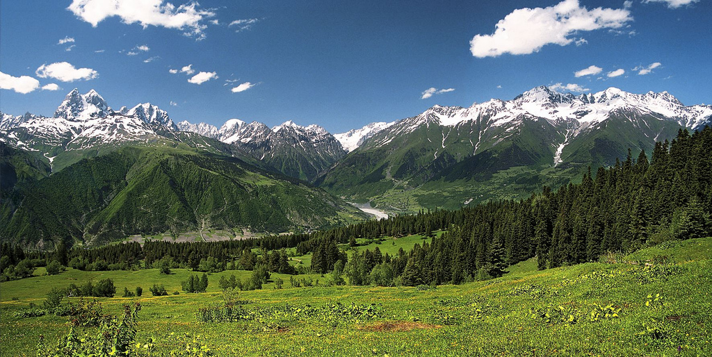
Have a look at these two pictures.

Alps (grayish white rocks towering over green high mountain pastures)


Dinaric mountains (Alps) (grayish white rocks towering over green high mountain pastures)


So what does this have to do with Gaelic?

In Gaelic we have this cluster based on the root word ail - stone, rock:

aill, -e, pl. id., and ailltreacha (Aran), f., a cliff, a rock; cf., an Áill, the "Naul" Co. Dublin (also faill, f., bárr na faille, the top of the cliff).
ailleort - high-rocked; from ail, rock
aill-bhruachach - having steep or rocky brinks. 
ailleadóir- cliff-climber.
ailbhinn - flint, precipice; from ail - rock.

From the same root ail - large stone, rock we have this word:


ailp, pl. alpa - a protuberance, a huge lump, a high mountain; a stout person

In Gaelic we also have this word:

bán - white which comes from Proto-Indo-European "bʰeh₂-" meaning - "white", "shining"

From these two words ail and bán we can make the construct: 

ail bán - alban - rock white - white rocks, white peaks, high mountains

What is also very interesting is that in Irish  the word "ailbh" means "flock, heard, drove".... Is this word derived from the fact that flocks, herds were driven up to the mountain pastures, ailban, alpen, alps, every summer? This is a high mountain pasture from Slovenian Alps.


In A.D. 875 Scotland was still known under its Roman name: Caledonia. Caledonia was in turn divided among the following lands: the Kingdom of Alban, the Northern Islands, and the Borders, which include the Kingdom of Strathclyde, Galloway, and the northern portions of the Kingdom of Northumbria. 


The kingdom of Alban lied mostly along the great Grampian Mountains. These are highland pastures lying under the great Grampian Mountains:


This is a picture of the highland pastures under the Matterhorn peak, Valais Alps, Switzerland.


Do you see any similarity? High pastures with grayish white rocky peaks?

Alba is the Scottish Gaelic name (Pronounced Alpa) for Scotland. It is cognate to Alba (gen. Albann, dat. Albainn) in Irish and Nalbin in Manx, the two other Goidelic Insular Celtic languages, as well as words in the Brythonic Insular Celtic languages of Cornish (Alban) and Welsh (Yr Alban) that also, in modern practice, are the Goidelic and Brythonic names for Scotland; although in the past they were names for Britain as a whole, related to the Brythonic name Albion. The term first appears in classical texts as Ἀλβίων Albíon or Ἀλουΐων Alouíon (in Ptolemy's writings in Greek), later as Albion in Latin documents. Historically, the term refers to Britain as a whole. Is this name derived from the appearance of the white cliff of Dover, which is the first thing anyone crossing the Channel and approaching Britain would see? So when Gaels first approached Britain, and they was the white cliffs, they would have probably named the land they were about to land on "ail bán" = white cliff land. And if later a Greek traveller crossing into britain asked the Gaelic speaking natives what was the name of this new land (pointing at the white cliffs), they would probably tell him "ail bán" = white cliff? And hey presto, we have a name for this new land of white cliffs...(Thank you Tim for pointing this to me)


Gaelic speakers in Scotland used Alba (dative Albainn, genitive Albann, now obsolete) as the name given to the former kingdom of the Picts which lied along the Great Grampian Mountains, which is full of white greyish white rocky peaks covered in snow. Did the name originally just mean "white peaks", "the land of white peaks"? Not too many of those in Ireland, so it must have been some sight for the invading Gaels. So a fitting name for the new foreign land...

In the High Medieval period Alban became re-Latinized as "Albania". This latter word was employed mainly by Celto-Latin writers, and most famously by Geoffrey of Monmouth. It was this word which passed into Middle English as Albany, although very rarely was this used for the Kingdom of Scotland, but rather for the notional Duchy of Albany.
So is Gaelic ail bán - Alban - rock white - white rocks the root of the word Alpen, Alp? What is the relationship of this phrase and the Latin albus, Ancient Greek ἀλφός ‎(alphós) and Hittite alpas? Are they related at all? Is the Gaelic phrase the root of all these other words? Or is all this just a coincidence?

Is it possible that by the early Iron Age, the expression "ail bán", or some of the dialectal versions of this expression, entered Ancient Greek and Latin from Gaelic, or some other dialect of Celtic languages, in the meaning of white cliffs, white rocks, white peaks? And is it possible that this is why Greeks and Romans named the region lying along the Greater Caucaus - Albania?

Caucasian Albania (Latin: Albānia, Greek: Ἀλβανία, Albanía, in Old Armenian: Աղուանք Ałuankʿ (Aguank), Parthian: Ardhan, Middle Persian: Arran; Georgian: რანი, Rani); is a name for the historical region of the eastern Caucasus, that existed on the territory of present-day republic of Azerbaijan (where both of its capitals were located) and partially southern Dagestan. The territory lies on the southern part of the Greater Caucasus range.


Caucasian mountains (grayish white rocks towering over green high mountain pastures)

-ia is a word-forming element in names of countries, diseases, flowers, from Latin and Greek -ia, which forms abstract nouns of feminine gender. In paraphernalia, Mammalia, etc. it represents the Latin and Greek plural suffix of nouns in -ium or -ion. 

So Albania is Alban + ia = ail + ban + ia = the land, country of white clifs, white peaks = Greater Caucasus

And it is the same with the Balkan Albania, which only appeared in records in Early Medieval time. The highest peaks of the Dinaric range are found in its southern part which lies in Montenegro, Serbia and Albania. Viewed from the coast, you see giant rocky peaks covered with snow looming over green pastures. So was Albania used here just as a name for the land of white cliffs, white peaks?


Let me know what you think about all this. 


Thursday, 30 July 2015

Mogila na Rake


Several early Bronze age tumulus graves have been discovered and excavated in Montenegro in last 10 years. They are concentrated in the fertile Zeta and Bojana valleys, both of which are linked to the Skadar lake. I already wrote about the Bjelopavlići tumulus. This time I will write about the tumulus known as "Mogila na rake" or "Spič tumulus" which was discovered in 2011.

Spič tumulus (Mogila na rake)

Tumulus which was found in the Spič field just south of Sutomore, under the Nehaj fortress is a tumulus type grave with a central dolmen cist which was built from a massive stone plates. It is estimated to be almost 5000 years old, dating to the early 3rd millennium BC, more precisely to 2700 BC. This is one of the so called princely graves common for southern Europe of that period.

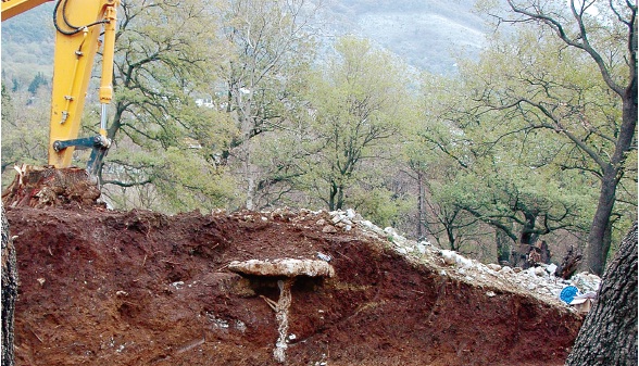
This is a completely new archaeological locality. It was discovered by pure accident while people were clearing part of an old forest to build a house. Here is a picture of the first sight of the dolmen cist emerging from the tumulus mound.


This is what the dolmen cist looks like after all the soil was cleared away.


According to the archaeologists the tumulus was built by the people who belonged to the early bronze Age Ljubljana culture. This culture seem to have stretched along the whole East Adriatic coast. It also seem to have stretched inland into Bosnia and all the way to Sava and Danube where it could have had contacts with Vučedol culture.

The original tumulus had the radius of about 15 m and the height of about 1.80 m. The dolmen cist is surrounded by a ring of stones, which ritually separates the land of the dead from the land of the living. The sacred area was carefully cleared and compacted. It was then covered with fine dry soil and then treated with fire. Only then the central dolmen was built. The dolmen was made from massive stone plates. The person buried inside this dolmen cist was buried in a foetal position. This symbolizes rebirth after death and points to a belief that the death was seen as a new birth. Once the deceased was placed inside the cist, the cist was sealed with several types of clay, making the grave completely watertight The inside of the grave was as dry as when it was initially sealed almost 5000 years ago.  

This is the translation of the excavation report filed by archaeologist Mladen Zagarčanin who lead the excavation:

The Early Bronze Age tumulus “Mogila na Rake“ from Sutomore was found on the northeastern part of Spič field, about 1 km from the sea. The big earth-stone tumulus which had diameter of about 15 m, and height of about 1.80 m. It was discovered during the works related to the clearing of a private land with the use of diggers. During the dig the majority of the western and northeastern part of the tumulus was destroyed. The excavation work stopped when the digger uncovered the cover plate of the central tomb dolmen cist.

This is a rough cross section diagram of the tumulus:


The tumulus was covered with a layer consisting of large river pebbles.


After removing the stone layer the removal of the red-brown earth layer, about 0.80 to 1.00m thick, was carried out. There were almost no stones in this layer, although now and then one could notice particles of grime, small fragments of broken flint and small pieces of atypical pottery. The excavation of the earth mound confirmed the dense concentration of small and big stones, about 1.20 m thick, from which the stone layer was formed, covering the middle of the conical pile of pressed red coloured clay. The diameter of this layer was about 3.20 m, and the height about 0.80 m.
Further excavation revealed, the layer of green-dark earth, partly mixed with grime, which was roughly piled along the dolmen cist walls up to 0.60 cm height. Several fragments of pottery were found in this layer, as well as larger amount of chipped stone , while a smaller flat stone construction was confirmed on the north side of the same layer. We can assume that this construction represents a stair abutting the tomb, and it could have served as a platform from where the person in charge of the burial carried out the ritual.

With the removal of the green-dark layer the base of lower stone covering was revealed, round in shape, and made of medium and small pieces of limestone (0.5 to 0.20 m) mixed with red-brown earth. The cist was built on this layer using local stones. The sides were  constructed from massive trapezoidal shape stone plates (1.40 × 1.00 m, about 20 cm thick), which were bonded with yellow waterproof clay.

The cist was covered with two massive rectangle shaped plates (1m x 1.20m and 1.80 × 1 m; 20 cm thick), a large amount of yellow green clay was added to the layer of green-dark clay, whose purpose was to cover the plates both above and below, providing in that way the hydro insulation of the tomb interior.

Before the funeral ceremony, the interior of the cist was covered with a layer of fine sea sand, and the body was put on top of it in a foetal position, with the head directed toward to west, arms folded at the elbow, and with folded legs.


The anthropological analyses showed that the buried person was a man in his forties or fifties who had serious problems with his spine during his lifetime. During the detailed bone examination, it was concluded that he suffered of osteoporosis, or bone loss. It was also concluded that arthrosis, or arthritis was present among the ilium bones, as well as diseases of peripheral joints because of degenerative changes in joint cartilage. The third bone disease was found in the lumbar area and sacrum. The deformation found here indicates that the deceased walked with problems during his lifetime and that he suffered great pain in his back. These diseases suggest that he spent much time on horse back, because those deformities are characteristic for riders.

What is very interesting is that this was not the only skeleton found in the cist.

The bones of a child 8-10 years old (teeth and parts of other bones were preserved) were found his legs, as well as a smaller number of bones of a person 25-30 years old. The archaeologists assume that those are the bones of close family members, perhaps his son and wife who died before him. The missing skull and other bones of the buried skeletons point to the possibility that their bones were excavated from some other place and put in this tomb later on. But there is also a possibility that the woman and the child were sacrificed and then buried with the man. 

The cist did not contain any metal objects which is strange for these types of graves from this period. This could mean that this is not a grave of a warrior but a person who was in some other way important. Like a priest.

What was found in the cist are two ceramic vessels: a jug and a shallow plate.

The plate has a thick ring shaped stand and was thus interpreted as a thurible, a vessel used for burning incense during rituals. The thurible is richly decorated on both sides. The cross shaped detail was drawn on the upper surface which was shaped as a shallow plate with the extracted front and rounded back part, formed by the ribbons filled with the crossed lines. The ribbon ornaments formed borders which go along the edge of the vessel. Two holes were made on the corners of the extracted part of the thurible. On the bottom, a star shaped detail was engraved, formed of triangle fields and filled with crossed lines.


Now have a look at the cross symbol drawn on the top surface of the thurible. Remember the grave is dated to 2700 BC:


Is this pattern just a decoration with no meaning? Well if the above incense burning vessel was the only vessel with this symbol found in Montenegro we could say that this is indeed just a meaningless decorative pattern. But exactly the same vessels were found in other tumuluses and some of them are even older than this tumulus and were dated to the end of the 4th millennium BC. Surely the pattern choice was deliberate and must have had some cultural or maybe even religious meaning. I will talk about these other tumuluses and why they are extremely important for understanding of the Early Bronze Age Irish history in my next post. For now, let me just ask you a question: do you remember the gold cross discs which the Early Bronze Age Irish copper miners loved so much? The ones I wrote about in my post Or -Ireland's gold

This is the pair of these "Irish" golden discs found in Monaghan, dated to 2200 - 2000 BC.


Remember that I said that these "Irish" cross discs were made from gold that was brought into Ireland from Cornwall? The gold which was, according to the Irish annals, brought to Ireland by Partholon? The same Pathalon which according to the Irish "pseudo histories" came from the Balkans, via Iberia sometime during the second half of the 3rd millennium BC? 

Please note the cross symbols on the discs. This is the same cross symbol found on the thurible from the Sutomore dolmen. Is this just a coincidence? I don't think so. Not just because there are several incense burning vessel with this symbol found in Montenegro. But also because the same tumuluses which contain the incense burning vessel with this symbol also contain golden discs with this symbol... And all of them predate the Irish gold cross discs and because it all fits perfectly into the story of Partholon found in the old Irish histories.

But more about it in my next posts. Until then stay happy.

Thursday, 13 November 2014

How did oaks repopulate Europe?

In my post about oaks I talked about the oak tree and how useful this tree was and still is to people. In this post I would like to explain why I believe that people were as useful to the oak trees as the oak trees were useful to people. I believe that the influence that people had on the distribution of oaks in Europe could have been far greater then it is currently accepted. I think that the northward spreading of oaks from their glacial refugiums after the last ice age was actually the result of the northward spreading of humans from the same refugiums. I believe that it was humans who brought the oaks to the north of Europe. Let me explain why I believe that that was the case.


As I said in my last post, fossil pollen evidence in Europe indicates that during the last Glacial Maximum (20 000 years ago), oak species were confined to three main Pleistocene refugiums in southern Europe: Iberia, Italy and the Balkans. Then around 17,000 BC, the global temperature started to increase which resulted in melting of the great Northern Hemisphere ice sheets. This melt down lasted until about 4,000 BC, and the result was a global warming and the increase in sea levels. But this increase in temperature, warming and sea level increase was not uniform. If we look at the global sea levels, we see that during the period of the big melt down, 17,000 BC to about 4,000 BC, they rose by a total of more than 120 meters. This means that if the temperature increase was uniform, the average rate of sea-level rise would have been roughly 1 meter per century. However, when we look at the actual sea level rise figures, we see that the gradual sea level rise at an average rate of 1 meter per century was interrupted by two periods with rates of rise up to 2.5 meters per century, during period 13 000 - 11 000 BC, and period 11 000 -  9 000 BC. The first of these jumps in the amount of ice-sheet melt water entering the world ocean coincides with the beginning of a period of global climate warming called the Bølling-Allerød period. The Bølling-Allerød period was a warm and moist period that occurred during the final stages of the last glacial period. This warm period began around 12,700 BC and ended abruptly around to 10,700 BC. This is the beginning of the cold period called Younger Dryas, also known as "the big freeze". This cold period is thought to have been caused by the collapse of the North American ice sheets. The temperatures in the North Hemisphere were reduced back to near-glacial levels within a decade. Younger Dryas lasted between 10,800 and 9500 BC, when we see the second big jump in temperature and resulting sea level rise rate. 

During Younger Dryas period, most of Eurasia and North America had been covered by tundra with swaths of taiga.The tundra biome is the coldest of all the biomes. Tundra comes from the Finnish word "tunturi", meaning treeless plain. It is noted for its frost-molded landscapes, extremely low temperatures, little precipitation, poor nutrients, and short growing seasons. 

 
Taiga is a high latitude northern hemisphere biome consisting mostly of conifer (fir) and birch forest. Temperature regimes within some of the taiga areas are among the lowest on Earth, since there is a continental aspect to the interior portions of the taiga, making it colder than many locations in the polar desert to the north. Extreme minimums in the taiga are typically lower than those of the tundra. 


So this is what most of the north of Europe was like during the Younger Drias.

Younger Drias was succedded by the Preboreal stage of the Holocene epoch. Preboreal stage lasted from 8,300 to 7,000 BC. It is the first stage of the Holocene epoch. The Preboreal started with an abrubt climate change which resulted in rapid rise of the global temperature and rapid rise of sea waters.

During the Preboreal period, large quantities of tree pollen began to replace the pollen of open-land species, as the most mobile and flexible arboreal (tree) species colonised their way northward, replacing the ice-age tundra plants. Foremost among them were the birches, accompanied by rowan also known as mountain-ash (known as jasen in Serbian) and aspen (known as jasika in Serbian).

This is a rowan tree:


This is an aspen tree:


Especially sensitive to temperature changes and moving northward almost immediately were the dwarf and shrub juniper (known as kleka in Serbian) respectively, which reached a maximum density in the Preboreal, before their niches were shaded out. This is a juniper bush:


Pine soon followed, for which reason the resulting open woodland is often called a birch or a pine-birch forest:


In the yet warmer early Boreal period (7000 - 5500 BC) hazel and pine expanded into the birch woodlands to such a degree that palynologists refer to the resulting ecology as the hazel-pine forest. I am not sure exactly what these forests used to look like because they don't exist any more, but maybe they looked something like this. This is old hazel forest from Britain:


In the late Boreal it was supplanted by the spread of a deciduous forest called the mixed-oak forest. Pine, birch and hazel were reduced in favour of oaks, elm, lime (linden) and alder. The former tundra was now closed by a canopy of dense forest.


Those interested in climatic and vegetative conditions in Europe over the last 150,000 years will find this web page quite interesting.

It is currently accepted that oak started to emerge from refugiums in southern Europe as the ice caps began to retreat at the end of the Younger Drias around 9500 BC. Oaks arrived in North Central Europe by the 8500 BC and to Eastern Britain by 7500 BC. 

But how did the oak forests expand from the southern Europe into Central Europe and Northern Europe? 

How do forests expand? A tree grows out of a seed. This seed falls from the tree branch on the ground and if it falls onto a fertile soil it sprouts into another tree. If the seed falls straight down from the branch the next tree generation will sprout at the distance of the furthest branch reach from the tree trunk, which is maximum 36 meters.


If the seed is light and can be carried by wind, and is falling from a big height during a strong wind, it can be carried away maybe up to the maximum tree height distance from the trunk, which could be up to a 120 meters and maybe even more.

If the tree grows near water and produces fruit or seed which can float on water then the seed can end up anywhere down stream from the tree. If the tree produces fruit which has tiny indigestible seeds, and if the fruit is eaten whole by birds or animals or humans, then the seed can be spread far and wide and deposited during defecation. 

Knowing all this we can understand why biologists believe that forests expand in general at a pace between 250-500 meters per year.

But I believe that the above estimate does not apply to oaks. Oak seed is acorn, and acorns are among some of the heaviest tree seeds in northern hemisphere. So oak seeds can't be carried away very far by the wind so the maximum acorn fall distance from the tree trunk is not more than few meters from the edge of the tree crown. This means that the next generation of oaks sprouting from the fallen acorns will sprout at maximum 40 meters from the parent tree. Oak produces edible seeds, acorns, which are encased in a protective hard shell.


Animals which eat acorns actually eat the seed. To get to the seed they have to break the protective shell and then they chew and eat the seed itself. Once the unprotected chewed seed eds up in a digestive system, it has not chance of sprouting again. There are three creatures that do collect whole acorns, carry then away from the tree and then bury them. These creatures are squirrels, jay birds and people.

Jays are strikingly coloured members of the crow family. 


Like the other members of the crow family, they are shown to be extremely intelligent, and in fact to be as good at problem solving as a seven year old human at a problem solving task. It can be found over a vast region from Western Europe and north-west Africa to the Indian Subcontinent and further to the eastern seaboard of Asia and down into south-east Asia.


Its diet includes a wide range of invertebrates including many pest insects, beech mast and other seeds, fruits such as blackberries and rowan berries, young birds and eggs, bats, and small rodents. Its favourite food is acorns, and jey birds are often found near oaks. Jays collect and bury acorn in large cashes throughout autumn which they then use as food sources during the winter. A single bird can bury up to a several thousand acorns each year, playing a crucial role in the spread of oak woodlands.

Even though they are the birds of the forest edge, they are unlikely to venture into the open as they are very poor fliers and can be caught easily by any raptor bird. So jay birds probably contributed to the spread of oaks through the original hazel-pine forests but they were hardly responsible for spreading oaks into the open grasslands. Also how far would a jay bird carry the acorns from the oak tree before burying them? Jay birds are extremely territorial and would defend their territory from all intruders. This type of behaviour means that jays are unlikely to spread the acorns too far from the oak under which they found the acorns. I could not find any precise data about the territory radius of jay birds, but I would say that it is definitely not bigger than one kilometer. So the furthest jay birds would spread the acorns from the oak tree would be up to few kilometers and only through the already existing forest.


Squirrels are agile tree dwelling members of the rodent family.


They are found in many regions of the world, including Europe, Asia and the Americas. There are many subspecies of which the most wide spread is the red squirrel or Eurasian red squirrel which is common throughout Eurasia.
 

Squirrels primarily eat nuts and seeds, but will also eat berries, fungus and insects. Squirrels horde food in small amounts in several locations when it's abundant. Although the red squirrel remembers where it created caches at a better-than-chance level, its spatial memory is not very accurate and durable. It therefore will often have to search for its food caches when it needs them, and many are never found again. These forgotten caches of seeds, if they were buried in the ground, instead become seedlings.

Arboreal predators which pray on squirrels include small mammals such as the pine marten, wild cats, and the stoat, which preys on nestlings as well as foxes which will pray on grown animals in the open as well as birds, including owls and raptors such as the goshawk and buzzards. Squirrels are extremely vulnerable on the ground and in the grassland which is why they never venture too far from trees.

The squirrel foraging home range consist of several acres that overlap the home ranges of other squirrels. Squirrels do not defend these territories. However, there is a dominance hierarchy with others of the same species. In general, older males are dominant over females and younger squirrels. Although they seldom stray farther than few hundred meters from their nest in any one season, they are known to travel up to a few kilometres to get to a good nut tree.So the furthest squirrels would be able to spread the acorns from the oak tree would be a few kilometres and only through the already existing forest.

So neither squirrels nor jay birds were very likely to take acorns out of the forest into the open grassland and bury them there. But people are actually likely to do exactly that as human settlements were usually out in the open near the forest edge.


People would collect the acorns in the forest and then bring them to their settlement and store them in pits dug in the ground. Any acorn dropped anywhere along the way could sprout into a new oak tree. What is more, people could have carried acorns with them during their seasonal hunting or fishing migrations up north in the spring and down south in the autumn or in and out of the steppe while chasing large game. Those acorns could have been brought as the source of starch food, as acorns remain in good condition for a long time and are easy to transport. In my post about acorns in archaeology i presented enough evidence that acorns were a staple starch food of most European Mesolithic and Neolithic communities. So Mesolithic people traveling across Europe with bags of acorns is not a possibility any more but a certainty. Any acorns lost or thrown away would have sprouted along the migration or hunting routes and then spread from there radially.

Oaks are said to have spread originally along the river valleys and then from the river valleys they spread into the surrounding hills. So it is presumed that oaks spread along these river valleys through normal forest creep on the same side of the river and through acorns falling into the water and then being carried away by the current down stream and diagonally across to the other side of the river. In theory this sounds plausible. In practise this is impossible to happen as acorns don't float. Actually the only acorns that do float are fungus infested, worm ridden dead acorns. The way to separate good acorns from bad ones is to dunk them into water and throw away any acorn that floats. So acorns which fall from the oak tree into the water sink straight down to the bottom and would never sprout.

Even if by any chance any of the good acorns did end up floating, they would have been carried down stream, southward not northward, as all rivers flowing just above the glacial refugiums flow southwards. But oaks did spread northwards along the big rivers. They managed to cross from the Balkans into the Panonian basin across giant rivers like Danube and Sava which completely cut the Balkans off from the rest of Europe.


The only place where Balkans is connected to the rest of Europe by land is in Slovenia where we find the Alps. The maximum elevation on which oaks are found is about 1500 meters above the sea level so oaks would have had a great problem finding their way from the Balkans into the Central Europe through the Alps by themselves even with the help of the squirrels and jay birds.

But acorns could have easily been carried up and across the big rivers in dugout canoes by Mesolithic people who lived along the European coast and major rivers and who used rivers as waterways along which they traveled into the center of the European continent. These Mesolithic fishermen could have carried acorns up rivers as the source of starch food. And these acorns could have been dropped by accident or discarded anywhere along the river and on either sides of the river, where they would have sprouted into young new oaks. This would have allowed oaks to quickly spread from the Balkans refugium into the Central Europe and to be already growing in the Main river valley between 8500 and 8000 BC.


This is the Hohenheim chronology of the Oak finds in Germany. You can see that we find oaks in Rhine and Main valleys even before 8000 BC:


If the Main valley oaks came from the Balkan peninsula then they had to cross about 1500 km from the north Balkans to Main valley. During that trip they had to cross high mountains (Alps) and big rivers (Danube, Sava).  If the Main valley oaks came from the Iberian peninsula then they also had to cross about 1500 km from the north Iberia to Main valley. During that trip they had to cross high mountains (Pyrenees‎) and big rivers (Garonne, Rhone, Loire). If the oaks started their expansion from the Balkans or the Iberia immediately after the end of the Younger Dryas, around 9500 BC, that would mean that they had to move at the speed of over 1 km a year to get to the Main river valley on time. These must have been some very speedy, all swimming, all mountain climbing, all singing, all dancing oaks....Not like the oaks we find today...

We have the same problem if we look at the chronology of the British oaks. The first oaks were found to have arrived in Britain around 7500 BC. From there it took oaks 2000 years to reach Scotland. Based on genetic evidence, most British oaks came from the Iberian refugium.

The direct shortest distance between north Spain and southern Britain is about 1500 km. Oaks are supposed to have started spreading at some stage after 9500 BC and have arrived to Britain 2000 years later. If we accept what biologists are saying, that oak forests expand in general at maximum pace of 500 meters per year, it would take oaks 3000 years to get to Britain which means that they would not have made it in time to be found in Britain at 7500 BC. 

But the path that oaks had to travel from Iberia to Britain was not straight and there were many high mountains and rivers which oaks needed to cross on their way up north.


This would all extend the distance the oaks needed to cross on their march to Britain to about 2500 km. This means that oaks would need at least 5000 years to expand from Iberia to Britain by expanding at the rate of 500 meters a year.

To make things worse according to latest data the Rhine, combined with the Schelde and Meuse, flowed to the south into the English Channel.


The above map shows the latest insights into how the North Sea was formed. Previously, scientists thought that the Rhine-Meuse-Schelde flowed to the north eventually joining the Ouse. But that idea proved to be wrong. One of the reasons for the southerly course of the Rhine was the forebulge that existed in the north of Holland. The weight of the ice cap upon Scandinavia pushed the earth's crust down and the crust bulged up to the south of it. Once the ice had gone, this bulge gradually flattened. Since 18000 BC, the north of Holland has sunk some 30m. The south of Britain also used to be higher than today. As the water rose quickly we can safely assume that the Channel extended fast to the north, rendering the distance from the south of France longer by each passing day. This would extend the distance that oaks had to cover between the north Iberia and south of Britain even more to maybe 3000 km. This means that oaks would need at least 6000 years to expand from Iberia to Britain by expanding at the rate of 500 meters a year.

But this is all based on a completely wrong premise that oak forest edge can move outwards at the rate between 250 and 500 meters a year, which is actually impossible. Oak forest edge can't move at the rate of even a 250 meter per year. The reason for that is that new oak tree will not produce any acorns until the tree is at least 25 years old. If we take this into account we get the real natural oak forest expansion speed.

If the acorn just falls down and sprouts it can't fall more than the maximum height or diameter of the tree which is not more than 120 meters. At best, if we take into account a possibility of an adventurous jay bird or a squirrel, which would take an acorn as far away as possible from the oak tree to bury it, that would still mean that the acorn would end up no more than few kilometres from the tree trunk. If the acorn then managed to sprout into a new oak, the expansion of the edge of the oak forest would then stop for next 25 years until the new oaks growing at the new edge of the oak forest start producing their own acorns. This means that the oak forests edge would not move 500 meters a year but at most 5000 meters (5 km) every 25 years. This would mean that even if we accept that the distance that oaks needed to cover to get from the north Iberia to the southern England or from the Balkans to the Main valley was only 1500 km, it would have taken oaks 12 500 years to cover that distance by "natural" means.

But if people brought oaks with them, travelling in their dugout canoes along the Atlantic coast, then oaks could have arrived to Britain from their Iberian refugium within a few years. Equally if people brought oaks with them, travelling in their dugout canoes up the river Danube and then down the river Rhine, then oaks could have arrived to Britain from their Balkan refugium within a few years. 

This means that there is a strong possibility that oaks did not spread naturally back into northern Europe from the Mediterranean refugiums . There is a strong possibility that oaks were imported into Britain and Ireland, and into the rest of northern Europe by the migrating hunters-gatherers and fishermen. For these Mesolithic boat people rivers were not barriers.  They actually used rivers as their main migration pathways. This is why we find that the oak expansion pattern is along river valleys and then radially into the hills. 

There is actually a direct proof that acorns were were spread into northern Europe from their Mediterranean refugiums by people. And it can be found in Walsh Marches. Based on genetic evidence, most British oaks came from the Iberian refugium. But not all. The oak population from the border between England and Wales (the Welsh Marches) possessed a haplotype which is common in the Balkan area. This means that it is possible that Britain had been recolonized by oaks from more than one refugium. How did these Balkan oaks arrive to England and Wales? The distance between Balkans and Wales is at least 2500 km. Just imagine how long it would have taken Balkan oaks to arrive to Wales if they were to be spread only by acorn drop, or by squirrels and jay birds...And by the way the closest oaks possessing the same genetic type as Welsh oaks, are scattered individuals along the north coast of France and in a clustered population near Rennes, 300 and 450 km distance from the Welsh Marches. This completely removes the possibility that the Welsh Marches oaks arrived by means of forest creep. They had to be brought to Wales from the Balkans by people.  The only question is when.

It's even not unthinkable that the Mesolithic people has deliberately sown acorns. It's one of the easiest things to do. You stick the acorn into the ground and forget about it. The young trees do not require attention and can take care of themselves. It takes 25 years until new oaks started to produce acorns. But once they do start to produce acorns, they would continue producing them for hundreds of years and would give one of the biggest yields per year of any edible plant. I believe that this must have been known to Mesolithic people and there is more and more evidence that Mesolithic people deliberately planted and cultivated "wild" crops millenniums before "agriculture" was invented. 

I will talk about cultivation versus agriculture in one of my next posts. Until then have fun.